Category:Klosterkirche Marienfließ
Jump to navigation
Jump to search
| Object location | | View all coordinates using: OpenStreetMap |
|---|
  | |||||
| Upload media | |||||
| Instance of | |||||
|---|---|---|---|---|---|
| Part of | |||||
| Location | Marienfließ, Prignitz District, Brandenburg, Germany | ||||
| Heritage designation | |||||
 | |||||
This is the category of the Brandenburger Baudenkmal (cultural heritage monument) with the ID 09160579 (Wikidata)
|
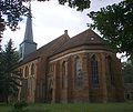
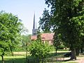
Deutsch: Die Klosterkirche Ss. Maria und Maria Magdalena in Stepenitz (zu Marienfließ), Mark Brandenburg, gehört und dient einer Gemeinde der unierten Evangelischen Kirche Berlin-Brandenburg-Schlesische Oberlausitz. Die Kirche entstand in der zweiten Hälfte des 13. Jahrhunderts und erhielt 1829 einen Dachturm.
English: The Cloister Church of Ss. Mary and Mary Magdalene in Stepenitz (a locality of Marienfließ), March of Brandenburg, Germany, is owned and used by a congregation within the Evangelical Church of Berlin-Brandenburg-Silesian Upper Lusatia, a united Protestant church body of Calvinist, Lutheran and united congregations. The church was erected in the 2nd half of the 14th c., its spire was added in 1829.
Subcategories
This category has only the following subcategory.
Media in category "Klosterkirche Marienfließ"
The following 14 files are in this category, out of 14 total.
-
 19870919300NR Stepenitz Klosterkirche Marienfließ.jpg 3,000 × 2,414; 6.17 MB
-
 19870919310NR Stepenitz Klosterkirche Marienfließ.jpg 2,516 × 2,996; 5.79 MB
-
 Kirche Kloster Marienfließ-Stepenitz.jpg 2,436 × 1,614; 2.7 MB
-
 Kloster Marienfließ1.JPG 560 × 420; 68 KB
-
 Klosterkirche Marienfließ 2016 Infotafel.jpg 3,648 × 4,864; 5.06 MB
-
 Klosterkirche Marienfließ 2016 S.jpg 4,864 × 3,648; 6.66 MB
-
 Klosterkirche Marienfließ 2016 SE.jpg 4,864 × 3,648; 10.42 MB
-
 Marienfliess Stepenitz church.jpg 1,140 × 960; 335 KB
-
 Marienfließ3.JPG 420 × 560; 88 KB
-
 Marienfließ6.JPG 640 × 480; 97 KB
-
 Marienfließ7.JPG 640 × 433; 104 KB
-
 Stepenitz Stift Marienfliess Klosterkirche 03.jpg 5,211 × 3,360; 13.04 MB
-
 Stepenitz Stift Marienfliess Klosterkirche 04.jpg 5,253 × 3,484; 13.29 MB
-
 Stepenitz Stift Marienfliess Klosterkirche 05.jpg 3,237 × 4,363; 7.74 MB


