Category:Kleterstraat 1-3, Nijkerk
Jump to navigation
Jump to search
| Object location | | View all coordinates using: OpenStreetMap |
|---|
 | |||||
| Upload media | |||||
| Instance of |
| ||||
|---|---|---|---|---|---|
| Location | Nijkerk, Gelderland, Netherlands | ||||
| Street address |
| ||||
| Located on street |
| ||||
| Heritage designation |
| ||||
 | |||||
|
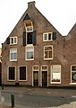
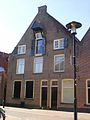
This is a category about rijksmonument number 30987
|
| Address |
|
Media in category "Kleterstraat 1-3, Nijkerk"
The following 8 files are in this category, out of 8 total.
-
 Achtergevels - Nijkerk - 20166824 - RCE.jpg 1,200 × 962; 279 KB
-
 Dorpsgezicht, reproductie van prentbriefkaart - Nijkerk - 20166709 - RCE.jpg 982 × 1,200; 235 KB
-
 Nijkerk-Kleterstraat 1+3.jpg 1,715 × 2,425; 689 KB
-
 Nijkerk-kleterstraat-05260006.jpg 1,200 × 1,600; 361 KB
-
 Overzicht rechterzijgevel - Nijkerk - 20166826 - RCE.jpg 1,200 × 1,200; 278 KB
-
 Overzicht voor- rechterzijgevel - Nijkerk - 20166825 - RCE.jpg 1,185 × 1,200; 298 KB
-
 Rechterzijgevel - Nijkerk - 20166827 - RCE.jpg 1,190 × 1,200; 281 KB
-
 Voorgevels - Nijkerk - 20166823 - RCE.jpg 1,200 × 945; 210 KB


