Category:Kleiweg 2, Baambrugge
Jump to navigation
Jump to search
| Object location | | View all coordinates using: OpenStreetMap |
|---|
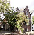
building in De Ronde Venen, Netherlands  | |||||
| Upload media | |||||
| Instance of | |||||
|---|---|---|---|---|---|
| Location | Baambrugge, Utrecht, Netherlands | ||||
| Street address |
| ||||
 | |||||
| Address |
|
Media in category "Kleiweg 2, Baambrugge"
The following 4 files are in this category, out of 4 total.
-
 Aanzicht voor- en achter - Baambrugge - 20026681 - RCE.jpg 1,193 × 1,200; 367 KB
-
 Aanzicht voor- en achter - Baambrugge - 20026682 - RCE.jpg 1,195 × 1,200; 333 KB
-
 Baambrugge - Kleiweg 2 RM6989.JPG 3,321 × 3,400; 1.68 MB
-
 Kleiweg-Brugstraat - Baambrugge - 20026680 - RCE.jpg 1,191 × 1,200; 287 KB


