Category:Kirchenruine Ganzer
Jump to navigation
Jump to search
| Object location | | View all coordinates using: OpenStreetMap |
|---|
This is the category of the Brandenburger Baudenkmal (cultural heritage monument) with the ID 09170543 (Wikidata)
|
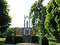
English: Ruin of Ganzer church, Wusterhausen municipality, Ostprignitz-Ruppin district, Brandenburg state, Germany
Deutsch: Ruine der Dorfkirche in Ganzer, Gemeinde Wusterhausen/Dosse, Landkreis Ostprignitz-Ruppin, Land Brandenburg, Deutschland.
Français : Ruine de l'église de Ganzer, commune de Wusterhausen/Dosse, arrondissement Prignitz-de-l'Est-Ruppin, état fédéral de Brandebourg, Allemagne
 | |||||
| Upload media | |||||
| Instance of | |||||
|---|---|---|---|---|---|
| Location | Ganzer, Wusterhausen/Dosse, Ostprignitz-Ruppin District, Brandenburg, Germany | ||||
| Heritage designation | |||||
 | |||||
Subcategories
This category has only the following subcategory.
I
Media in category "Kirchenruine Ganzer"
The following 14 files are in this category, out of 14 total.
-
 Denkmal Jürgaß Kirchenruine Ganzer Text 1.jpg 4,000 × 3,000; 3.27 MB
-
 Denkmal Jürgaß Kirchenruine Ganzer Text 2.jpg 3,000 × 4,000; 4.22 MB
-
 Denkmal Jürgaß Kirchenruine Ganzer Text 3.jpg 3,000 × 4,000; 4.41 MB
-
 Denkmal Jürgaß Kirchenruine Ganzer Text 4.jpg 3,000 × 4,000; 2.86 MB
-
 Denkmal Jürgaß Kirchenruine Ganzer.jpg 3,000 × 4,000; 3.55 MB
-
 Denkmal Jürgaß vor der Kirchenruine Ganzer Rückseite.jpg 3,456 × 4,608; 6.21 MB
-
 Denkmal Jürgaß vor der Kirchenruine Ganzer.jpg 4,608 × 3,456; 6.54 MB
-
 Kirchenruine Ganzer 2016 E.jpg 4,864 × 3,648; 5.68 MB
-
 Kirchenruine Ganzer 2016 Glockenstuhl.jpg 3,648 × 4,864; 5.41 MB
-
 Kirchenruine Ganzer 2016 S.jpg 4,864 × 3,648; 6.12 MB
-
 Kirchenruine Ganzer 2016 SW.jpg 4,864 × 3,648; 5.68 MB
-
 Kirchenruine Ganzer Ostseite mit Glockenstuhl.jpg 4,608 × 3,456; 6.44 MB
-
 Kirchenruine Ganzer Südseite.jpg 4,608 × 3,456; 6.38 MB
-
 Kirchenruine Ganzer Südwestseite.jpg 4,608 × 3,456; 6.4 MB


