Category:Kirche Wilmersdorf (Briesen)
Jump to navigation
Jump to search
| Object location | | View all coordinates using: OpenStreetMap |
|---|
church building in Brandenburg state, Germany  | |||||
| Upload media | |||||
| Instance of | |||||
|---|---|---|---|---|---|
| Location | Briesen, Oder-Spree District, Brandenburg, Germany | ||||
| Heritage designation | |||||
 | |||||
This is the category of the Brandenburger Baudenkmal (cultural heritage monument) with the ID 09115330 (Wikidata)
|
Media in category "Kirche Wilmersdorf (Briesen)"
The following 25 files are in this category, out of 25 total.
-
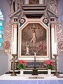 2004-12-13 Wilmersdorf (Briesen) Altar.jpg 600 × 800; 131 KB
-
 2004-12-13 Wilmersdorf (Briesen) Anna selbdritt.jpg 1,536 × 2,048; 610 KB
-
 Dorfkirche Wilmersdorf Chor nördlicher Anbau Ostseite.jpg 3,024 × 4,032; 3 MB
-
 Dorfkirche Wilmersdorf Chor Südansicht.jpg 3,024 × 4,032; 2.99 MB
-
 Dorfkirche Wilmersdorf Findling.jpg 4,032 × 3,024; 4.49 MB
-
 Dorfkirche Wilmersdorf Informationstafel Kirche (FoP-Germany).jpg 4,032 × 3,024; 2.54 MB
-
 Dorfkirche Wilmersdorf Kirchenschiff Epitaph Anbau.jpg 3,024 × 4,032; 4.59 MB
-
 Dorfkirche Wilmersdorf Kirchenschiff Epitaph Südseite.jpg 3,024 × 4,032; 4.15 MB
-
 Dorfkirche Wilmersdorf Kirchenschiff Nordseite Anbau Ostansicht.jpg 3,024 × 4,032; 2.79 MB
-
 Dorfkirche Wilmersdorf Kirchenschiff Nordseite Anbau.jpg 3,024 × 4,032; 3.23 MB
-
 Dorfkirche Wilmersdorf Kirchenschiff Nordseite hinterer Teil.jpg 3,024 × 4,032; 3.82 MB
-
 Dorfkirche Wilmersdorf Kirchenschiff Nordseite vorderer Teil.jpg 4,032 × 3,024; 3.54 MB
-
 Dorfkirche Wilmersdorf Kirchenschiff Südansicht hinterer Teil.jpg 3,024 × 4,032; 4.33 MB
-
 Dorfkirche Wilmersdorf Kirchenschiff Südansicht.jpg 3,024 × 4,032; 4.51 MB
-
 Dorfkirche Wilmersdorf Kirchenschiff Südseite Anbau.jpg 3,024 × 4,032; 3.43 MB
-
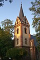
 Dorfkirche Wilmersdorf Ostansicht.jpg 3,024 × 4,032; 3.24 MB
-
 Dorfkirche Wilmersdorf Südwestansicht.jpg 3,024 × 4,032; 4.83 MB
-
 Dorfkirche Wilmersdorf Westturm Erdgeschoss.jpg 3,024 × 4,032; 4.15 MB
-
 Dorfkirche Wilmersdorf Westturm Nordansicht.jpg 3,024 × 4,032; 2.33 MB
-
 Dorfkirche Wilmersdorf Westturm Nordwestansicht.jpg 3,024 × 4,032; 5.73 MB
-
 Dorfkirche Wilmersdorf Westturm Obergeschosse.jpg 3,024 × 4,032; 4.43 MB
-
 Dorfkirche Wilmersdorf Westturm Südansicht.jpg 3,024 × 4,032; 2.57 MB
-
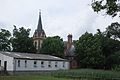 Madlitz-Wilmersdorf Kirche.jpg 3,872 × 2,592; 1.14 MB
-
 Wilmersdorf (Briesen)-Kirche.jpg 1,600 × 2,400; 999 KB
-
 Wilmersdorf - Dorfkirche - panoramio.jpg 480 × 640; 68 KB
_Altar.jpg)
_Anna_selbdritt.jpg)


.jpg)


-Kirche.jpg)
