Category:Kirche St. Matthias (Dürler)
Jump to navigation
Jump to search
| Object location | | View all coordinates using: OpenStreetMap |
|---|
church in Dürler, Belgium .jpg) | |||||
| Upload media | |||||
| Instance of | |||||
|---|---|---|---|---|---|
| Dedicated to | |||||
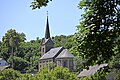
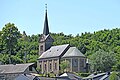
| Location | Dürler, Burg-Reuland, Arrondissement of Verviers, Province of Liege, Walloon Region, Belgium | ||||
| Diocese | |||||
 | |||||
Media in category "Kirche St. Matthias (Dürler)"
The following 12 files are in this category, out of 12 total.
-
 Dürler 01.jpg 6,048 × 4,024; 3.33 MB
-
 Dürler 2010 001 (1).jpg 4,311 × 2,874; 4.52 MB
-
 Dürler-Kirche St. Matthias (1).jpg 4,032 × 2,268; 3.24 MB
-
 Dürler-Kirche St. Matthias (2).jpg 4,032 × 2,268; 2.73 MB
-
 Dürler-Kirche St. Matthias (3).jpg 2,268 × 4,032; 3.46 MB
-
 Dürler-Kirche St. Matthias (4).jpg 4,032 × 2,268; 5.6 MB
-
 St. Matthias (Dürler) 01.jpg 6,048 × 4,024; 2.43 MB
-
 St. Matthias (Dürler) 02.jpg 5,170 × 3,446; 1.91 MB
-
 St. Matthias (Dürler) 03.jpg 4,322 × 2,881; 3.36 MB
-
 St. Matthias (Dürler) 04.jpg 4,732 × 3,154; 4.17 MB
-
 St. Matthias (Dürler) 05.jpg 3,228 × 5,014; 2.08 MB
-
 St. Matthias (Dürler) 06.jpg 5,464 × 3,642; 6.32 MB

.jpg)
.jpg)
.jpg)
.jpg)
_01.jpg)
_02.jpg)
_03.jpg)
_04.jpg)
_05.jpg)
_06.jpg)