Category:Kirche Oberburg BE
Jump to navigation
Jump to search
| Object location | | View all coordinates using: OpenStreetMap |
|---|
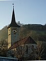
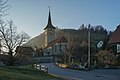
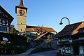
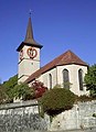
church building and building ensemble in Oberburg in the canton of Bern, Switzerland _und_Kirche_(1497)_in_Oberburg_BE.jpg) Kirche rechts, mit Pfarrhaus links im Bild .jpg) | |||||
| Upload media | |||||
| Instance of | |||||
|---|---|---|---|---|---|
| Part of | |||||
| Location | Oberburg, Emmental administrative district, Emmental-Oberaargau administrative region, Bern, Switzerland | ||||
| Street address |
| ||||
| Architectural style | |||||
| Has part(s) | |||||
| Heritage designation | |||||
| Inception |
| ||||
| official website | |||||
 | |||||
Subcategories
This category has only the following subcategory.
P
Media in category "Kirche Oberburg BE"
The following 20 files are in this category, out of 20 total.
-
 Chorfenster Oberburg BE (1).jpg 1,968 × 5,741; 6.44 MB
-
 Chorfenster Oberburg BE (2).jpg 1,780 × 4,977; 5.83 MB
-
 Kirche Oberburg BE (1).jpg 6,000 × 4,000; 11.08 MB
-
 Kirche Oberburg BE (10).jpg 6,000 × 4,000; 9.14 MB
-
 Kirche Oberburg BE (11).jpg 3,798 × 4,559; 7.91 MB
-
 Kirche Oberburg BE (12).jpg 6,000 × 4,000; 13.44 MB
-
 Kirche Oberburg BE (13).jpg 6,000 × 4,000; 13 MB
-
 Kirche Oberburg BE (14).jpg 3,042 × 4,000; 6.93 MB
-
 Kirche Oberburg BE (15).jpg 5,613 × 3,742; 10.9 MB
-
 Kirche Oberburg BE (2).jpg 6,000 × 4,000; 12.03 MB
-
 Kirche Oberburg BE (3).jpg 5,641 × 3,761; 8.58 MB
-
 Kirche Oberburg BE (4).jpg 4,000 × 6,000; 8.85 MB
-
 Kirche Oberburg BE (5).jpg 6,000 × 4,000; 8.7 MB
-
 Kirche Oberburg BE (6).jpg 4,000 × 6,000; 8.89 MB
-
 Kirche Oberburg BE (7).jpg 4,000 × 6,000; 9.1 MB
-
 Kirche Oberburg BE (8).jpg 6,000 × 4,000; 9.66 MB
-
 Kirche Oberburg BE (9).jpg 3,699 × 5,548; 7.96 MB
-
 Kirche oberburg.jpg 251 × 345; 23 KB
-
 Kirchgasse mit Pfarrhaus (1749) und Kirche (1497) in Oberburg BE.jpg 4,200 × 3,165; 10.13 MB
-
 Kirchgemeindehaus Oberburg.jpg 6,000 × 4,000; 17.33 MB
.jpg)
.jpg)
.jpg)
.jpg)
.jpg)
.jpg)
.jpg)
.jpg)
.jpg)
.jpg)
.jpg)
.jpg)
.jpg)
.jpg)


.jpg)
.jpg)