Category:Kirche (Wölflinswil)
Jump to navigation
Jump to search
| Object location | | View all coordinates using: OpenStreetMap |
|---|
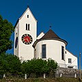
church buildings and part of an architectural ensemble in Wölflinswil in the canton of Aargau, Switzerland  | |||||
| Upload media | |||||
| Instance of | |||||
|---|---|---|---|---|---|
| Part of | |||||
| Location | Wölflinswil, Laufenburg District, Aargau, Switzerland | ||||
| Street address |
| ||||
| Architectural style | |||||
| Has part(s) | |||||
| Heritage designation | |||||
| Inception |
| ||||
 | |||||
Subcategories
This category has the following 2 subcategories, out of 2 total.
P
- Pfarrhaus (Wölflinswil) (1 F)
- Pfarrscheune (Wölflinswil) (1 F)
Media in category "Kirche (Wölflinswil)"
The following 2 files are in this category, out of 2 total.
-
 2018-Woelflinswil-KIrche.jpg 1,280 × 1,280; 1.7 MB
-
 2018-Woelflinswil-Kirchenensemble.jpg 1,920 × 1,080; 2.31 MB
