Category:Kerkstraat 26, Makkum
Jump to navigation
Jump to search
| Object location | | View all coordinates using: OpenStreetMap |
|---|
 | |||||
| Upload media | |||||
| Instance of |
| ||||
|---|---|---|---|---|---|
| Location | Makkum, Friesland, Netherlands | ||||
| Street address |
| ||||
| Located on street | |||||
| Heritage designation |
| ||||
 | |||||
|
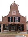
This is a category about rijksmonument number 39387
|
| Address |
|
Media in category "Kerkstraat 26, Makkum"
The following 5 files are in this category, out of 5 total.
-
 2023 Makkum, Tsjerkestrjitte 26.jpg 1,594 × 1,600; 1.02 MB
-
 Gevels - Makkum - 20150369 - RCE.jpg 1,200 × 809; 210 KB
-
 Gevels - Makkum - 20150371 - RCE.jpg 807 × 1,200; 178 KB
-
 Kerkstraat in zuidelijke richting - Makkum - 20150279 - RCE.jpg 1,191 × 1,200; 285 KB
-
 Kerkstraat26 Makkum.jpg 2,736 × 3,648; 750 KB


