Category:Kerkstraat 2, Hattem
Jump to navigation
Jump to search
| Object location | | View all coordinates using: OpenStreetMap |
|---|
 | |||||
| Upload media | |||||
| Instance of |
| ||||
|---|---|---|---|---|---|
| Location | Hattem, Gelderland, Netherlands | ||||
| Street address |
| ||||
| Located on street |
| ||||
| Heritage designation |
| ||||
 | |||||
|
This is a category about rijksmonument number 20967
|
| Address |
|
Media in category "Kerkstraat 2, Hattem"
The following 11 files are in this category, out of 11 total.
-
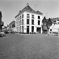
 2007-04-23 11.05 Hattem, straatzicht centrum.JPG 2,272 × 1,704; 1.2 MB
-
 Hoek Kruisstraat 8, aanzicht - Hattem - 20103299 - RCE.jpg 1,200 × 808; 181 KB
-
 Hoekbebouwing Kerkstraat - Hattem - 20103360 - RCE.jpg 969 × 1,200; 223 KB
-
 Markt 9 +0, voorgevels - Hattem - 20103363 - RCE.jpg 806 × 1,200; 179 KB
-
 Overzicht met Markt 8 - Hattem - 20103302 - RCE.jpg 1,193 × 1,200; 294 KB
-

-
 Voor en zijgevel - Hattem - 20103303 - RCE.jpg 1,200 × 1,200; 300 KB
-
 Voor- en zijgevel - Hattem - 20103304 - RCE.jpg 1,200 × 1,200; 291 KB
-
 Voorgevel - Hattem - 20103305 - RCE.jpg 1,195 × 1,200; 295 KB
-
 Voorgevel - Hattem - 20103364 - RCE.jpg 1,200 × 1,200; 286 KB
-
 Zijgevel - Hattem - 20103306 - RCE.jpg 1,195 × 1,200; 311 KB


