Category:Kerkring 13, Willemstad
Jump to navigation
Jump to search
| Object location | | View all coordinates using: OpenStreetMap |
|---|
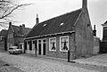
house in Moerdijk, Netherlands  | |||||
| Upload media | |||||
| Instance of | |||||
|---|---|---|---|---|---|
| Location | Willemstad, North Brabant, Netherlands | ||||
| Street address |
| ||||
| Located on street |
| ||||
| Heritage designation |
| ||||
 | |||||
|
This is a category about rijksmonument number 38954
|
| Address |
|
Media in category "Kerkring 13, Willemstad"
The following 4 files are in this category, out of 4 total.
-
 Aanzicht - Willemstad - 20214300 - RCE.jpg 3,308 × 2,224; 1.4 MB
-
 Kerkring oost zijde - Willemstad - 20214115 - RCE.jpg 1,200 × 950; 338 KB
-
 Kerkring oost zijde - Willemstad - 20214117 - RCE.jpg 1,200 × 959; 313 KB
-
 Willemstad - rijksmonument 38954 - Kerkring 13 20120115.jpg 632 × 800; 233 KB


