Category:Kerkplein 28, Zaltbommel
Jump to navigation
Jump to search
| Object location | | View all coordinates using: OpenStreetMap |
|---|
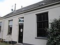
building in Zaltbommel, Netherlands  | |||||
| Upload media | |||||
| Instance of | |||||
|---|---|---|---|---|---|
| Location | Zaltbommel, Gelderland, Netherlands | ||||
| Street address |
| ||||
| Located on street | |||||
| Heritage designation |
| ||||
 | |||||
|
This is a category about rijksmonument number 40191
|
| Address |
|
Media in category "Kerkplein 28, Zaltbommel"
The following 3 files are in this category, out of 3 total.
-
 Kerkplein 28.jpg 4,000 × 3,000; 809 KB
-
 Overzicht - Zaltbommel - 20220397 - RCE.jpg 1,200 × 808; 224 KB
-
 Voorgevel - Zaltbommel - 20220398 - RCE.jpg 1,200 × 812; 225 KB

