Category:Kerkhofstraat 9, Hattem
Jump to navigation
Jump to search
| Object location | | View all coordinates using: OpenStreetMap |
|---|
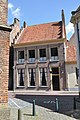
house in Hattem, Netherlands  | |||||
| Upload media | |||||
| Instance of | |||||
|---|---|---|---|---|---|
| Location | Hattem, Gelderland, Netherlands | ||||
| Street address |
| ||||
| Located on street |
| ||||
| Heritage designation | |||||
 | |||||
|
This is a category about rijksmonument number 20948
|
| Address |
|
Media in category "Kerkhofstraat 9, Hattem"
The following 8 files are in this category, out of 8 total.
-
 A 421 - Hattem - 20103254 - RCE.jpg 962 × 1,200; 293 KB
-
 A 421 met omgeving - Hattem - 20103255 - RCE.jpg 964 × 1,200; 262 KB
-
 A 421, achterzijde - Hattem - 20103252 - RCE.jpg 957 × 1,200; 278 KB
-
 Hattem, Netherlands - panoramio (43).jpg 2,048 × 1,155; 503 KB
-
 Hattem20948.JPG 2,848 × 4,288; 6.72 MB
-
 Voorgevel - Hattem - 20103263 - RCE.jpg 803 × 1,200; 220 KB
-
 Voorgevels - Hattem - 20103261 - RCE.jpg 814 × 1,200; 219 KB
-
 Zijgevels - Hattem - 20103265 - RCE.jpg 817 × 1,200; 210 KB


.jpg)


