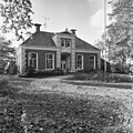
Category:Kerkbrink 6, Anloo
Jump to navigation
Jump to search
| Object location | | View all coordinates using: OpenStreetMap |
|---|
 | |||||
| Upload media | |||||
| Instance of | |||||
|---|---|---|---|---|---|
| Location | Anloo, Aa en Hunze, Drenthe, Netherlands | ||||
| Street address |
| ||||
| Located on street |
| ||||
| Heritage designation |
| ||||
 | |||||
|
This is a category about rijksmonument number 510977
|
| Address |
|
Media in category "Kerkbrink 6, Anloo"
The following 2 files are in this category, out of 2 total.
-
 Kerkbrink 6 Anloo.jpg 1,664 × 1,324; 370 KB
-
 Voorgevel - Anloo - 20022745 - RCE.jpg 1,197 × 1,200; 440 KB
