Category:Keresley
Jump to navigation
Jump to search
village in West Midlands, England, Britain  | |||||
| Upload media | |||||
| Instance of | |||||
|---|---|---|---|---|---|
| Location | Coventry, West Midlands, England | ||||
| Population |
| ||||
| Area |
| ||||
| Said to be the same as | Keresley (Wikimedia duplicated page, civil parish) | ||||
 | |||||
Media in category "Keresley"
The following 99 files are in this category, out of 99 total.
-
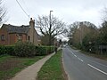
 A farm track leading to Fivefield Road, Keresley - geograph.org.uk - 3795840.jpg 1,200 × 798; 341 KB
-
 A former AA Patrol Service Car - geograph.org.uk - 3791590.jpg 1,200 × 798; 416 KB
-
 A path leading to Fivefield Road, Keresley - geograph.org.uk - 3795837.jpg 1,200 × 798; 478 KB
-
 A path leading to Tamworth Road - geograph.org.uk - 3795907.jpg 1,200 × 798; 229 KB
-
 A pond near Keresley - geograph.org.uk - 3795910.jpg 1,200 × 798; 560 KB
-
 Ash Tree House on Sandpits Lane - geograph.org.uk - 3795929.jpg 1,200 × 798; 425 KB
-
 Bennett's Road North - geograph.org.uk - 5309618.jpg 640 × 480; 72 KB
-
 Bennett's Road North, Keresley - geograph.org.uk - 5309624.jpg 640 × 480; 52 KB
-

-

-
 Bennetts Road South from Keresley fields - geograph.org.uk - 6849146.jpg 2,592 × 1,936; 1.84 MB
-
 Bridge over Hall Brook - geograph.org.uk - 3795917.jpg 1,200 × 798; 591 KB
-
 Britannia Royal Court Hotel, Coventry, England-12July2008.jpg 4,865 × 1,755; 3.64 MB
-

-
 Canada geese ^ goslings on pond near Hall Brook, Keresley - geograph.org.uk - 6849153.jpg 2,592 × 1,936; 2.62 MB
-
 Cardinal Newman School on Sandpits Lane - geograph.org.uk - 3795933.jpg 1,200 × 798; 405 KB
-
 Carved wooden faces, Fivefield Road, Keresley - geograph.org.uk - 6832301.jpg 2,592 × 1,936; 1.93 MB
-
 Close up, George VI postbox on Tamworth Road - geograph.org.uk - 5311441.jpg 1,660 × 2,754; 1,011 KB
-
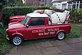 Concrete Mini-mix Van on Keresley Road - geograph.org.uk - 3791594.jpg 1,200 × 798; 416 KB
-
 Coventry Colliery Social Club, Bennetts Road, Keresley - geograph.org.uk - 6838842.jpg 4,000 × 3,000; 2.95 MB
-
 Entering Coventry - geograph.org.uk - 5309620.jpg 640 × 480; 77 KB
-

-
 Fern House Farm on Tamworth Road - geograph.org.uk - 3793008.jpg 1,200 × 798; 298 KB
-
 Fivefield Road, Keresley - geograph.org.uk - 227273.jpg 640 × 480; 57 KB
-
 Fivefield Road, Keresley - geograph.org.uk - 3795850.jpg 1,200 × 798; 290 KB
-
 Footbridge over Hall Brook - geograph.org.uk - 2634214.jpg 640 × 388; 110 KB
-
 Footpath from Fivefield Road to edge of Bunsons Wood - geograph.org.uk - 6850771.jpg 1,936 × 2,592; 2.15 MB
-
 Footpath off Tamworth Road near Corley - geograph.org.uk - 3792411.jpg 1,200 × 798; 408 KB
-
 Footpath off Tamworth Road near Corley - geograph.org.uk - 3792467.jpg 1,200 × 798; 535 KB
-
 Former gatehouse at Royal Court Hotel - geograph.org.uk - 3792370.jpg 1,200 × 798; 402 KB
-
 Gate and kissing gate by Hall Brook, Keresley - geograph.org.uk - 6875528.jpg 2,592 × 1,936; 2.54 MB
-
 George VI postbox on Tamworth Road - geograph.org.uk - 5311438.jpg 1,872 × 2,840; 1,021 KB
-
 Grazing north of Penny Park Lane - geograph.org.uk - 5302551.jpg 640 × 480; 50 KB
-
 Grove House Rest Home - geograph.org.uk - 3792473.jpg 1,200 × 798; 402 KB
-

-
 Hare and Hounds, Keresley Green - geograph.org.uk - 227041.jpg 640 × 480; 73 KB
-
 Heap of rubble on site of Coventry Colliery Social Club - geograph.org.uk - 6865344.jpg 2,592 × 1,936; 1.88 MB
-
 Holy Family Church on Penny Park Lane - geograph.org.uk - 3501939.jpg 800 × 641; 152 KB
-
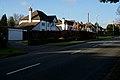
 Houses on Tamworth Road near Corley - geograph.org.uk - 3792505.jpg 1,200 × 798; 525 KB
-
 Houses on Tamworth Road near Corley - geograph.org.uk - 3792508.jpg 1,200 × 798; 254 KB
-
 Houses on Tamworth Road near Corley - geograph.org.uk - 3792706.jpg 1,200 × 798; 382 KB
-
 Houses on Tamworth Road near Corley - geograph.org.uk - 3792987.jpg 1,200 × 798; 535 KB
-
 Houses on Tamworth Road near Corley - geograph.org.uk - 3792988.jpg 1,200 × 798; 489 KB
-
 Houses on Tamworth Road near Corley - geograph.org.uk - 3792995.jpg 1,200 × 798; 419 KB
-
 Housing development on site of Coventry Colliery Social Club - geograph.org.uk - 6865347.jpg 2,592 × 1,936; 1.87 MB
-
 John Reay Golf Centre on Sandpits Lane - geograph.org.uk - 3795930.jpg 1,200 × 798; 456 KB
-
 Keresley Clinic - geograph.org.uk - 6010655.jpg 1,600 × 900; 255 KB
-
 Keresley Jubilee Wood - geograph.org.uk - 6875557.jpg 2,592 × 1,936; 2.28 MB
-
 Keresley United Reformed Church, Bennetts Road - geograph.org.uk - 6849138.jpg 2,592 × 1,936; 1.56 MB
-
 Keresley Wood Care Centre off Tamworth Road - geograph.org.uk - 3792698.jpg 1,200 × 753; 352 KB
-
 Keresley, Holy Family Church - geograph.org.uk - 4339607.jpg 768 × 1,024; 124 KB
-
 Keresley, Holy Family School - geograph.org.uk - 4339612.jpg 1,024 × 768; 139 KB
-
 Keresley, primary school - geograph.org.uk - 4018935.jpg 1,024 × 729; 123 KB
-
 Keresley, The Convoy - geograph.org.uk - 4339619.jpg 1,024 × 768; 204 KB
-
 Keresley, The Old Shepherd - geograph.org.uk - 4018921.jpg 1,024 × 768; 159 KB
-
 Land fenced off for building, Keresley Village - geograph.org.uk - 6913459.jpg 2,592 × 1,936; 1.95 MB
-

-
-
 Love Ukraine (72 293) (51934404367).jpg 5,185 × 3,324; 10.01 MB
-
 Manor Farm near Keresley - geograph.org.uk - 3795918.jpg 1,200 × 798; 272 KB
-
 Maplewood Independent Hospital - geograph.org.uk - 3792442.jpg 1,200 × 798; 406 KB
-

-
 No. 16 bus climbing Bennetts Road towards Keresley Village - geograph.org.uk - 6849133.jpg 2,592 × 1,936; 2.01 MB
-
 Path leading to Bennetts Road, Keresley - geograph.org.uk - 3795920.jpg 1,200 × 798; 434 KB
-
 Path leading to Hall Brook Road - geograph.org.uk - 3795925.jpg 1,200 × 798; 328 KB
-
 Path off Bennetts Road, Keresley - geograph.org.uk - 3795830.jpg 1,200 × 798; 447 KB
-
 Path off Fivefield Road, Keresley - geograph.org.uk - 3795853.jpg 1,200 × 798; 444 KB
-
 Path off Fivefield Road, Keresley - geograph.org.uk - 3795906.jpg 1,200 × 798; 305 KB
-
 Pine trees in grounds of Keresley Hall - geograph.org.uk - 6849123.jpg 2,592 × 1,936; 2.22 MB
-
 Pond with two miniature islands - geograph.org.uk - 6849155.jpg 2,592 × 1,936; 1.97 MB
-

-
 Public path off Bennetts Road, Keresley - geograph.org.uk - 3791614.jpg 1,200 × 798; 453 KB
-
 Recent neo-vernacular housing seen from field by Watery Lane - geograph.org.uk - 6875545.jpg 2,592 × 1,936; 2.86 MB
-
 Red Admiral butterfly, with a piece taken out - geograph.org.uk - 6943338.jpg 1,936 × 2,592; 2.11 MB
-
 Rustic roadside furniture, Fivefield Road, Keresley - geograph.org.uk - 6832292.jpg 2,592 × 1,936; 2.42 MB
-
 Severely pruned trees, Bennetts Road, Keresley - geograph.org.uk - 6849142.jpg 1,936 × 2,592; 1.51 MB
-

-
 Tamworth Road (B4098) - geograph.org.uk - 5311444.jpg 2,848 × 2,136; 1.16 MB
-
 Tamworth Road near Hollyfast Lane - geograph.org.uk - 3793004.jpg 1,200 × 798; 524 KB
-
 Tamworth Road towards Corley - geograph.org.uk - 3792440.jpg 1,200 × 798; 475 KB
-
 Tamworth Road towards Corley - geograph.org.uk - 3792475.jpg 1,200 × 798; 469 KB
-
 Tamworth Road towards Corley - geograph.org.uk - 3792488.jpg 1,200 × 798; 566 KB
-
 Tamworth Road towards Corley - geograph.org.uk - 3793010.jpg 1,200 × 798; 461 KB
-

-
 The Hare ^ Hounds, Keresley - geograph.org.uk - 3791609.jpg 1,200 × 798; 382 KB
-
 The Hare ^ Hounds, Keresley - geograph.org.uk - 3791612.jpg 798 × 1,200; 445 KB
-
 The Royal Court Hotel on Tamworth Road, Coventry - geograph.org.uk - 3791809.jpg 1,200 × 798; 501 KB
-
 The Royal Court Hotel on Tamworth Road, Coventry - geograph.org.uk - 3792283.jpg 1,200 × 798; 434 KB
-
 The Royal Court Hotel on Tamworth Road, Coventry - geograph.org.uk - 3792285.jpg 1,200 × 798; 419 KB
-
 The Royal Court Hotel on Tamworth Road, Coventry - geograph.org.uk - 3792366.jpg 1,200 × 798; 276 KB
-
 Thompson's Lane by Bunsons Wood, Keresley - geograph.org.uk - 6850767.jpg 1,936 × 2,592; 1.9 MB
-

-
 View across field to east of Hall Yard Wood, Keresley - geograph.org.uk - 6832259.jpg 2,592 × 1,936; 2.38 MB
-
 Walking on Keresley Fields - geograph.org.uk - 6849144.jpg 2,592 × 1,936; 2.37 MB
-
 Walking the dog in fields off Watery Lane, Keresley - geograph.org.uk - 6822618.jpg 2,592 × 1,936; 1.76 MB
-
 White Lion - geograph.org.uk - 269767.jpg 480 × 640; 97 KB
-
 Whitecroft on Bennetts Road, Keresley - geograph.org.uk - 3795827.jpg 1,200 × 798; 432 KB
-
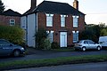
 House, former shop, Keresley Village - geograph.org.uk - 583417.jpg 640 × 427; 133 KB
-


_(51934404367).jpg)


_-_geograph.org.uk_-_5311444.jpg)


