Category:Kelburne, Paisley
Jump to navigation
Jump to search
An area of Paisley, Scotland, on its eastern edge, bounded by Incle Street (west), Glasgow railway line (north), Arkleston Road (east) and Glasgow Road (south).
Subcategories
This category has the following 2 subcategories, out of 2 total.
B
- Barshaw Drive railway bridge (2 F)
K
- Kelburne Cricket Club (2 F)
Media in category "Kelburne, Paisley"
The following 8 files are in this category, out of 8 total.
-
 Byres Hill - geograph.org.uk - 1220940.jpg 640 × 387; 72 KB
-
 Former ARP building on Kelburne Oval - geograph.org.uk - 427170.jpg 640 × 413; 109 KB
-
 Glasgow Road - geograph.org.uk - 1219914.jpg 640 × 480; 63 KB
-
 Greenlaw House - geograph.org.uk - 426603.jpg 480 × 640; 117 KB
-
 Railway line at Greenlaw Gardens - geograph.org.uk - 1220945.jpg 640 × 480; 66 KB
-
 Regent Street - geograph.org.uk - 426576.jpg 640 × 480; 104 KB
-
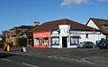 Shops on Arkleston Road - geograph.org.uk - 1219995.jpg 640 × 399; 55 KB
-
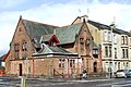 The Arthur Allison Memorial Hall - geograph.org.uk - 426575.jpg 640 × 425; 95 KB


