Category:Keizerstraat 35, Utrecht
Jump to navigation
Jump to search
| Object location | | View all coordinates using: OpenStreetMap |
|---|
building in Utrecht, Netherlands  | |||||
| Upload media | |||||
| Instance of | |||||
|---|---|---|---|---|---|
| Location | Utrecht, Netherlands | ||||
| Street address |
| ||||
| Heritage designation |
| ||||
 | |||||
|
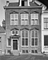
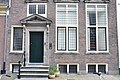
This is a category about rijksmonument number 36188
|
| Address |
|
Media in category "Keizerstraat 35, Utrecht"
The following 7 files are in this category, out of 7 total.
-
 Exterieur OVERZICHT VOORGEVEL - Utrecht - 20339860 - RCE.jpg 935 × 1,200; 241 KB
-
 Exterieur VOORGEVEL - Utrecht - 20339861 - RCE.jpg 960 × 1,200; 289 KB
-
 Ingang - Utrecht - 20235865 - RCE.jpg 853 × 1,200; 184 KB
-
 Keizerstraat 35 - Utrecht - boven.JPG 4,288 × 2,848; 5.2 MB
-
 Keizerstraat 35 - Utrecht - entree.JPG 2,848 × 4,288; 5.97 MB
-
 Keizerstraat 35 - Utrecht - onder.JPG 4,288 × 2,848; 5.97 MB
-
 Voorgevel - Utrecht - 20235864 - RCE.jpg 929 × 1,200; 250 KB


