Category:Keedysville Bridge
Jump to navigation
Jump to search
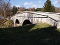
The Upper Crossing of Antietam Creek during the Civil War Battle of Antietam. The Keedysville Road Bridge, aka Hitt Bridge.
 | |||||
| Upload media | |||||
| Instance of | |||||
|---|---|---|---|---|---|
| Location | Washington County, Maryland | ||||
| Crosses |
| ||||
 | |||||
Media in category "Keedysville Bridge"
The following 2 files are in this category, out of 2 total.
-
 Upper Bridge P2060099.jpg 1,984 × 1,488; 1.96 MB
-
 Upper Bridge P2060100.jpg 1,984 × 1,488; 1.84 MB
