Category:Katholische Kirche St. Maria Magdalena (Dorf 22.1, Romoos)
Jump to navigation
Jump to search
| Object location | | View all coordinates using: OpenStreetMap |
|---|
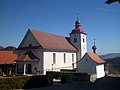
church building in Romoos in the canton of Lucerne, Switzerland  | |||||
| Upload media | |||||
| Instance of | |||||
|---|---|---|---|---|---|
| Part of | |||||
| Location | Romoos, Entlebuch Constituency, Lucerne, Switzerland | ||||
| Street address |
| ||||
| Heritage designation | |||||
 | |||||
Media in category "Katholische Kirche St. Maria Magdalena (Dorf 22.1, Romoos)"
The following 2 files are in this category, out of 2 total.
-
 Iglesia-Romoos-Lucerna-Suiza.JPG 4,288 × 3,216; 2.66 MB
-
 Lucerne - Romoos - Katholische Kirche St. Maria Magdalena.JPG 4,288 × 3,216; 2.32 MB
