Category:Kasteel Ulenpas
Jump to navigation
Jump to search
| Object location | | View all coordinates using: OpenStreetMap |
|---|
| Upload media | |||||
| Instance of | |||||
|---|---|---|---|---|---|
| Location | Hoog-Keppel, Bronckhorst, Gelderland, Netherlands | ||||
| Has part(s) | |||||
| Heritage designation |
| ||||
 | |||||
|
This is a category about rijksmonumentcomplex number 511848
|
Hoofdonderdeel:
|
This is a category about rijksmonument number 511849
|
Historische tuin- en parkaanleg:
|
This is a category about rijksmonument number 511850
|
Koetshuis:
|
This is a category about rijksmonument number 511851
|
Fazanterie:
|
This is a category about rijksmonument number 511856
|
Tuinvaas:
|
This is a category about rijksmonument number 511857
|
Hangbrug:
|
This is a category about rijksmonument number 511858
|
Inrijhek:
|
This is a category about rijksmonument number 511859
|
Tuinmuur:
|
This is a category about rijksmonument number 511860
|
Tuinschuur:
|
This is a category about rijksmonument number 511861
|
Stalgebouw:
|
This is a category about rijksmonument number 511862
|
Boswachterswoning:
|
This is a category about rijksmonument number 511863
|
| Address |
|
Media in category "Kasteel Ulenpas"
The following 57 files are in this category, out of 57 total.
-
 19e eeuwse vleugel. - Hoog-Keppel - 20115090 - RCE.jpg 1,200 × 803; 274 KB
-
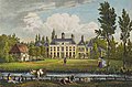
 34. Château d'Ulenpas, Province de Gueldre.jpg 1,044 × 701; 153 KB
-
 Brug - Hoog-Keppel - 20115104 - RCE.jpg 1,200 × 1,199; 515 KB
-
 Exterieur - Hoog-Keppel - 20115079 - RCE.jpg 1,200 × 1,197; 364 KB
-
 Exterieur - Hoog-Keppel - 20115080 - RCE.jpg 1,195 × 1,200; 377 KB
-
 Exterieur - Hoog-Keppel - 20115081 - RCE.jpg 1,200 × 1,197; 385 KB
-
 Exterieur - Hoog-Keppel - 20115082 - RCE.jpg 1,200 × 1,200; 384 KB
-
 Exterieur - Hoog-Keppel - 20115083 - RCE.jpg 1,200 × 1,200; 458 KB
-
 Exterieur - Hoog-Keppel - 20115084 - RCE.jpg 1,200 × 1,200; 412 KB
-
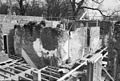
 Exterieur achter na de brand - Hoog-Keppel - 20115074 - RCE.jpg 1,200 × 968; 263 KB
-
 Exterieur BRUG MET TOEGANGSHEK - Hoog-Keppel - 20295640 - RCE.jpg 1,192 × 1,200; 503 KB
-
 Exterieur OVERZICHT - Hoog-Keppel - 20263016 - RCE.jpg 1,200 × 775; 220 KB
-
 Exterieur OVERZICHT ACHTERZIJDE MET PARK - Hoog-Keppel - 20339532 - RCE.jpg 1,183 × 1,200; 576 KB
-
 Exterieur OVERZICHT ACHTERZIJDE MET PARK EN BRUG - Hoog-Keppel - 20339529 - RCE.jpg 1,188 × 1,200; 407 KB
-
 Exterieur OVERZICHT ACHTERZIJDE MET PARK, TUINVAAS - Hoog-Keppel - 20339533 - RCE.jpg 1,174 × 1,200; 372 KB
-
 Exterieur OVERZICHT RECHTER ZIJGEVEL - Hoog-Keppel - 20263017 - RCE.jpg 1,200 × 775; 188 KB
-
 Exterieur OVERZICHT RECHTER ZIJGEVEL EN ACHTERGEVEL - Hoog-Keppel - 20339531 - RCE.jpg 1,183 × 1,200; 377 KB
-

-
 Exterieur OVERZICHT VOORGEVEL - Hoog-Keppel - 20263018 - RCE.jpg 1,200 × 775; 175 KB
-
 Exterieur OVERZICHT VOORGEVEL, LINKER ZIJGEVEL - Hoog-Keppel - 20339530 - RCE.jpg 1,183 × 1,200; 464 KB
-
 Exterieur TUINVAAS OP SOKKEL - Hoog-Keppel - 20339534 - RCE.jpg 1,176 × 1,200; 501 KB
-
 Exterieur voorzijde na de brand - Hoog-Keppel - 20115075 - RCE.jpg 1,200 × 959; 252 KB
-
 Gebogen toegangslaan naar het huis - Hoog-Keppel - 20263015 - RCE.jpg 1,200 × 775; 218 KB
-
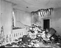 Hal interieur na de brand - Hoog-Keppel - 20115073 - RCE.jpg 1,200 × 958; 208 KB
-
 Hal met toegang tot opkamer - Hoog-Keppel - 20115095 - RCE.jpg 1,200 × 795; 236 KB
-
 Interieur - Hoog-Keppel - 20115085 - RCE.jpg 1,197 × 1,200; 299 KB
-
 Interieur - Hoog-Keppel - 20115086 - RCE.jpg 1,193 × 1,200; 376 KB
-
 Interieur - Hoog-Keppel - 20115087 - RCE.jpg 1,195 × 1,200; 352 KB
-
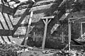
 Kamer interieur na de brand - Hoog-Keppel - 20115072 - RCE.jpg 1,200 × 936; 239 KB
-
 Kelderlicht in de voorgevel - Hoog-Keppel - 20115099 - RCE.jpg 1,200 × 809; 216 KB
-

-
 Noordgevel - Hoog-Keppel - 20115091 - RCE.jpg 1,200 × 788; 247 KB
-
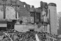 Noordzijde na sloop 19e eeuwse vleugel - Hoog-Keppel - 20115089 - RCE.jpg 1,200 × 803; 232 KB
-
 Oostelijk gedeelte zuidgevel - Hoog-Keppel - 20115103 - RCE.jpg 792 × 1,200; 285 KB
-
 Opkamer naar het westen - Hoog-Keppel - 20115097 - RCE.jpg 788 × 1,200; 272 KB
-
 Overzicht - Hoog-Keppel - 20115105 - RCE.jpg 1,195 × 1,200; 411 KB
-
 Overzicht voorgevel en rechter zijgevel - Hoog-Keppel - 20359526 - RCE.jpg 1,192 × 1,200; 312 KB
-
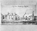 Prent - Hoog-Keppel - 20115076 - RCE.jpg 1,200 × 987; 288 KB
-
 Rechter zij- en achtergevel - Hoog-Keppel - 20115109 - RCE.jpg 1,192 × 1,200; 412 KB
-
 Rechter zijgevel - Hoog-Keppel - 20115108 - RCE.jpg 1,188 × 1,200; 409 KB
-
 Uitwendig aanzicht - Hoog-Keppel - 20115077 - RCE.jpg 1,200 × 1,124; 272 KB
-
 Uitwendig aanzicht - Hoog-Keppel - 20115078 - RCE.jpg 1,200 × 1,177; 323 KB
-
 Ulenpas hek.jpg 2,136 × 1,482; 506 KB
-
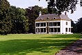
 Ulenpas hoog keppel.jpg 467 × 308; 82 KB
-
 Ulenpas.jpg 2,111 × 1,425; 484 KB
-
 Verdieping boven opkamer - Hoog-Keppel - 20115098 - RCE.jpg 1,200 × 805; 288 KB
-
 Verdieping boven opkamer naar het westen - Hoog-Keppel - 20115093 - RCE.jpg 1,200 × 806; 269 KB
-
 Verdieping naar het noord-oost - Hoog-Keppel - 20115102 - RCE.jpg 1,200 × 807; 279 KB
-
 Verdieping naar het oosten - Hoog-Keppel - 20115100 - RCE.jpg 1,200 × 799; 257 KB
-
 Verdieping naar het oosten - Hoog-Keppel - 20115101 - RCE.jpg 1,200 × 805; 298 KB
-
 Voor- en linker zijgevel - Hoog-Keppel - 20115107 - RCE.jpg 1,190 × 1,200; 319 KB
-
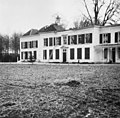
 Voorgevel - Hoog-Keppel - 20115069 - RCE.jpg 1,200 × 939; 244 KB
-
 Voorgevel - Hoog-Keppel - 20115070 - RCE.jpg 1,200 × 806; 204 KB
-
 Voorgevel - Hoog-Keppel - 20115106 - RCE.jpg 1,198 × 1,200; 331 KB
-
 Zuid-oost vertrek - Hoog-Keppel - 20115096 - RCE.jpg 1,200 × 788; 284 KB
-
 Zuid-oost vertrek op de verdieping - Hoog-Keppel - 20115094 - RCE.jpg 806 × 1,200; 191 KB
-
 Zuidzijde na sloop 18e en 19e eeuwse vleugel. - Hoog-Keppel - 20115088 - RCE.jpg 1,200 × 812; 255 KB


