Category:Kasteel Altenbroek
Jump to navigation
Jump to search
| Object location | | View all coordinates using: OpenStreetMap |
|---|
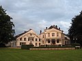
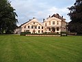
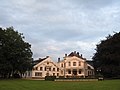
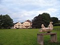
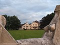
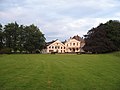
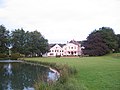
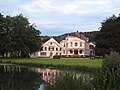
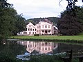
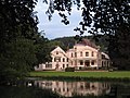
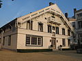
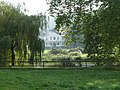
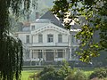
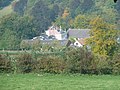
Nederlands: Afbeeldingen van het voormalige Kasteel Altenbroek ook wel Altembrouck genoemd, Altenbroek 4, 3798 Voeren, België. Gelegen in de gemeente Voeren in de provincie Limburg (Belgische provincie) in het noordoosten van België. Nabij het natuurgebied Altenbroek. Tegenwoordig is het een hotel en restaurant. (bron [1];[2])
|
This is a category about onroerend erfgoed number 37625
|
 | |||||
| Upload media | |||||
| Instance of | |||||
|---|---|---|---|---|---|
| Location | Voeren, Arrondissement of Tongeren, Limburg, Flemish Region, Belgium | ||||
| Heritage designation |
| ||||
 | |||||
Subcategories
This category has only the following subcategory.
K
Media in category "Kasteel Altenbroek"
The following 39 files are in this category, out of 39 total.
-
 Altembroek (33).JPG 3,264 × 2,448; 4.03 MB
-
 Altembroek (34).JPG 3,264 × 2,448; 3.53 MB
-
 Altembroek (35).JPG 3,264 × 2,448; 3.73 MB
-
 Altembroek (37).JPG 2,592 × 1,944; 1.69 MB
-
 Altembroek (38).JPG 3,264 × 2,448; 3.64 MB
-
 Altembroek (55).JPG 2,592 × 1,944; 1.11 MB
-
 Altembroek (56).JPG 2,592 × 1,944; 1.18 MB
-
 Altembroek (57).JPG 2,592 × 1,944; 1.11 MB
-
 Altembroek (58).JPG 2,592 × 1,944; 1.33 MB
-
 Altembroek (59).JPG 2,592 × 1,944; 1.31 MB
-
 Altembroek (60).JPG 2,448 × 3,264; 4.45 MB
-
 Altembroek (62).JPG 2,592 × 1,944; 1.01 MB
-
 Altembroek (63).JPG 2,592 × 1,944; 989 KB
-
 Altembroek (64).JPG 2,592 × 1,944; 1.34 MB
-
 Altembroek (65).JPG 2,592 × 1,944; 1.37 MB
-
 Altembroek (66).JPG 2,592 × 1,944; 1,013 KB
-
 Altembroek (67).JPG 2,592 × 1,944; 1.09 MB
-
 Altembroek (68).JPG 2,592 × 1,944; 982 KB
-
 Altembroek (69).JPG 2,592 × 1,944; 1.09 MB
-
 Altembroek (70).JPG 2,592 × 1,944; 1.06 MB
-
 Altembroek (71).JPG 2,592 × 1,944; 1.05 MB
-
 Altembroek (72).JPG 2,592 × 1,944; 1.13 MB
-
 Altembroek (73).JPG 2,592 × 1,944; 1.15 MB
-
 Altembroek (74).JPG 2,592 × 1,944; 1.3 MB
-
 Altembroek (75).JPG 2,592 × 1,944; 1.04 MB
-
 Altembroek (76).JPG 2,592 × 1,944; 1.08 MB
-
 Altembroek (77).JPG 2,592 × 1,944; 1.38 MB
-
 Altembroek (78).JPG 2,592 × 1,944; 1.3 MB
-
 Altembroek (79).JPG 2,592 × 1,944; 1.17 MB
-
 Altembroek (80).JPG 2,592 × 1,944; 1.07 MB
-
 Altenbrouck (10).JPG 3,264 × 2,448; 2.88 MB
-
 Altenbrouck (11).JPG 3,264 × 2,448; 2.76 MB
-
 Altenbrouck (235).JPG 2,592 × 1,944; 1.49 MB
-
 Altenbrouck (237).JPG 2,592 × 1,944; 1.16 MB
-
 Altenbrouck (238).JPG 2,592 × 1,944; 1.37 MB
-
 Gravenvoeren-Kasteel Altembrouck1.JPG 4,000 × 3,000; 4.85 MB
-
 Gravenvoeren-Kasteel Altembrouck2.JPG 4,000 × 3,000; 5.04 MB
-
 Gravenvoeren-Kasteel Altembrouck3.JPG 4,000 × 3,000; 4.52 MB
-
 Voeren Altembroek 4 - 256296 - onroerenderfgoed.jpg 1,440 × 1,026; 390 KB
.JPG)
.JPG)
.JPG)
.JPG)
.JPG)
.JPG)
.JPG)
.JPG)
.JPG)
.JPG)
.JPG)
.JPG)
.JPG)
.JPG)
.JPG)
.JPG)
.JPG)
.JPG)
.JPG)
.JPG)
.JPG)
.JPG)
.JPG)
.JPG)
.JPG)
.JPG)
.JPG)
.JPG)
.JPG)
.JPG)
.JPG)
.JPG)
.JPG)
.JPG)
.JPG)


