Category:Kardinal-Frings-Gymnasium
Jump to navigation
Jump to search
| Object location | | View all coordinates using: OpenStreetMap |
|---|
Private secondary school of the Roman Catholic Archdiocese of Cologne in Bonn, Germany  | |||||
| Upload media | |||||
| Instance of | |||||
|---|---|---|---|---|---|
| Named after |
| ||||
| Location | |||||
| Street address |
| ||||
| Located on street |
| ||||
| Operator | |||||
| Founded by | |||||
| Inception |
| ||||
| official website | |||||
 | |||||
Media in category "Kardinal-Frings-Gymnasium"
The following 4 files are in this category, out of 4 total.
-
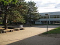
 2011-10-13 Bonn Kardinal-Frings-Gymnasium Beuel 1.JPG 3,264 × 2,448; 3.98 MB
-
 2011-10-13 Bonn Kardinal-Frings-Gymnasium Beuel 2.JPG 3,264 × 2,448; 4.83 MB
-
 2011-10-13 Bonn Kardinal-Frings-Gymnasium Beuel 3.JPG 3,264 × 2,448; 4.31 MB
-
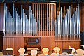 Walcker-Orgel in der Aula des Kardinal-Frings-Gymnasiums Bonn-Beuel.jpg 7,005 × 4,675; 3.85 MB


