Category:Kapelstraat 1, Bronkhorst
Jump to navigation
Jump to search
| Object location | | View all coordinates using: OpenStreetMap |
|---|
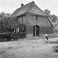
farmhouse in Bronckhorst, Netherlands  | |||||
| Upload media | |||||
| Instance of | |||||
|---|---|---|---|---|---|
| Location | Bronkhorst, Bronckhorst, Gelderland, Netherlands | ||||
| Street address |
| ||||
| Located on street |
| ||||
| Heritage designation |
| ||||
 | |||||
|
This is a category about rijksmonument number 34547
|
| Address |
|
Media in category "Kapelstraat 1, Bronkhorst"
The following 4 files are in this category, out of 4 total.
-
 Bronkhorst Kapelstraat1 34547.jpg 4,288 × 2,848; 6.66 MB
-
 Kapelstr. 1 - Bronkhorst - 20044066 - RCE.jpg 1,200 × 1,185; 350 KB
-
 Voor- en zijgevel nr. F 92-21 - Bronkhorst - 20494449 - RCE.jpg 1,200 × 900; 165 KB
-
 Zijgevel nr. F 92-22 - Bronkhorst - 20494450 - RCE.jpg 1,200 × 900; 165 KB


