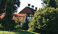
Category:Kapelle St. Philippus (Römerswil 7a, St. Ursen)
Jump to navigation
Jump to search
| Object location | | View all coordinates using: OpenStreetMap |
|---|
chapel in St. Ursen in the canton of Fribourg, Switzerland .jpg) | |||||
| Upload media | |||||
| Instance of | |||||
|---|---|---|---|---|---|
| Part of | |||||
| Location | St. Ursen, Sense District, Canton of Fribourg, Switzerland | ||||
| Street address |
| ||||
| Heritage designation |
| ||||
 | |||||
Media in category "Kapelle St. Philippus (Römerswil 7a, St. Ursen)"
The following 3 files are in this category, out of 3 total.
-
 St Ursen Römerswil EOS 400 066 (cropped).jpg 1,750 × 2,170; 1.34 MB
-
 St Ursen Römerswil EOS 400 066 (cropped2).jpg 2,386 × 1,736; 1.57 MB
-
 St Ursen Römerswil EOS 400 066.jpg 3,684 × 2,170; 3.16 MB
.jpg)
