Category:Kapelle Gosda
Jump to navigation
Jump to search
| Object location | | View all coordinates using: OpenStreetMap |
|---|
church building in Spree-Neiße district, Brandenburg state, Germany  | |||||
| Upload media | |||||
| Instance of | |||||
|---|---|---|---|---|---|
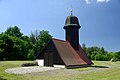
| Location | Gosda/Gózd, Wiesengrund, Spree-Neiße District, Brandenburg, Germany | ||||
 | |||||
English: Pictures of the chapel in Gosda/Gózd, Wiesengrund municipality, Spree-Neiße district, Brandenburg state, Germany.
Deutsch: Ansichten der Kapelle in Gosda/Gózd, Gemeinde Wiesengrund, Landkreis Spree-Neiße, Land Brandenburg, Deutschland.
Français : Photos de la chapelle à Gosda/Gózd, commune de Wiesengrund, arrondissement de Spree-Neiße, état fédéral de Brandebourg, Allemagne
Español: Vistas de la capilla en Gosda/Gózd, municipio de Wiesengrund, distrito de Spree-Neiße, estado federado de Brandeburgo, Alemania
Address: Gosdaer Dorfstraße 15, 03149 Wiesengrund
Media in category "Kapelle Gosda"
This category contains only the following file.
-
 Gosda - Tiefenkirche 0001.jpg 1,200 × 803; 261 KB