Category:Kapelle (Schälismühlestrasse 13, Oberbuchsiten)
Jump to navigation
Jump to search
| Object location | | View all coordinates using: OpenStreetMap |
|---|
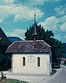
chapel building in Oberbuchsiten in the canton of Solothurn, Switzerland .jpg) Kapelle an Strassenrand | |||||
| Upload media | |||||
| Instance of | |||||
|---|---|---|---|---|---|
| Part of | |||||
| Location | Oberbuchsiten, Gäu District, Thal-Gäu, Solothurn, Switzerland | ||||
| Street address |
| ||||
| Heritage designation | |||||
 | |||||
Media in category "Kapelle (Schälismühlestrasse 13, Oberbuchsiten)"
The following 3 files are in this category, out of 3 total.
-
-
 Zentralbibliothek Solothurn Ernst Klöti 1324 Schaelismuehle (bearb Sp).jpg 6,161 × 4,018; 19.22 MB
-
 Zentralbibliothek Solothurn Ernst Klöti 1324 Schaelismuehle.jpg 6,415 × 4,184; 18.55 MB
.jpg)
