Category:Kanan Irrigation System
Jump to navigation
Jump to search
system of irrigation from Chinian Plain, Taiwan  | |||||
| Upload media | |||||
| Instance of | |||||
|---|---|---|---|---|---|
| Location |
| ||||
| Elevation above sea level |
| ||||
 | |||||
中文(臺灣):嘉南大圳
Subcategories
This category has only the following subcategory.
Media in category "Kanan Irrigation System"
The following 23 files are in this category, out of 23 total.
-
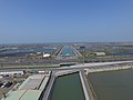
 03.12 總統出席「水圳綠道啟用典禮暨植樹活動」 (51933242329).jpg 2,048 × 1,285; 2.09 MB
-
 DJI 0021.JPG 4,000 × 3,000; 5.33 MB
-
 Jianan Dazun Map.svg 322 × 502; 46 KB
-
 Map of Kanan Irrigation System.jpg 3,332 × 2,768; 2.06 MB
-
 Officials at the inspection of construction of Kanan Irrigation System.jpg 2,048 × 1,459; 215 KB
-
 Rinnai control gates, Kanan Irrigation System.jpg 943 × 649; 332 KB
-
 Sluice gates, Uzanto, Kanan Irrigation System.jpg 943 × 532; 233 KB
-
 Steam excavator at the construction site of Kanan Irrigation System.jpg 1,200 × 710; 100 KB
-
 Taiwan formosa vintage history other places dams taipics007.jpg 791 × 514; 66 KB
-
 Water bridge over the Bokushi River 1930.jpg 1,200 × 472; 134 KB
-
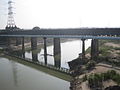
 嘉南大圳官田溪渡槽橋.jpg 5,472 × 3,648; 10.2 MB
-
 嘉南大圳曾文溪渡槽橋.JPG 1,600 × 1,200; 381 KB
-
 嘉南大圳渡仔頭溪渡槽橋.JPG 2,272 × 1,704; 1.16 MB
-
 嘉南大圳渡仔頭溪渡槽橋20160725-1.jpg 3,648 × 2,736; 2.5 MB
-
 嘉南大圳渡仔頭溪渡槽橋20160725-2.jpg 3,648 × 2,736; 3.21 MB
-
 嘉南大圳渡仔頭溪渡槽橋20160725-3.jpg 2,736 × 3,648; 4.7 MB
-
 嘉南大圳渡仔頭溪渡槽橋20160725-4.jpg 3,648 × 2,736; 3.05 MB
-
 嘉南大圳渡仔頭溪渡槽橋20160725-5.jpg 3,648 × 2,736; 2.99 MB
-
 嘉南大圳渡仔頭溪渡槽橋20160725-6.jpg 2,736 × 3,648; 3.35 MB
-
 嘉南大圳麻豆支線 - panoramio (1).jpg 3,072 × 2,304; 1.78 MB
-
 嘉南大圳麻豆支線 - panoramio.jpg 3,072 × 2,304; 2.15 MB
-
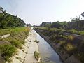
 安南嘉南大圳旁的環圳步道.jpg 2,560 × 1,920; 1.45 MB
-
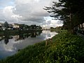 流經安南區的嘉南大圳(遠處為台19線安順橋).jpg 2,560 × 1,920; 1.31 MB
.jpg)


.jpg)


.jpg)