Category:Kanab Plateau
Jump to navigation
Jump to search

plateau in Arizona, USA .jpg) | |||||
| Upload media | |||||
| Instance of | |||||
|---|---|---|---|---|---|
| Location | Arizona | ||||
 | |||||
English: The Kanab Plateau — a plateau in northern Arizona.
- Located on the North Rim of the Grand Canyon — adjacent on the west to the Kaibab Plateau, with a basin containing the Kanab Creek watershed in between.
- Within the High Plateaus physiographic section of the Colorado Plateau physiographic province.
Subcategories
This category has the following 3 subcategories, out of 3 total.
K
Media in category "Kanab Plateau"
The following 9 files are in this category, out of 9 total.
-
 GrandCanyon.NASA.2014.jpg 1,440 × 960; 612 KB
-
-
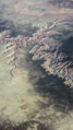
 Kanab Creek Canyon, Arizona (14223845173).jpg 4,000 × 3,000; 2.92 MB
-
 Kanab Creek Canyon, Arizona Strip (14017102147).jpg 4,000 × 3,000; 3.08 MB
-
 Kanab Creek Canyon, Arizona Strip (14200411331).jpg 4,000 × 3,000; 2.42 MB
-
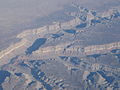 Kanab Creek Canyon, Arizona Strip (14200412501).jpg 4,000 × 3,000; 2.76 MB
-
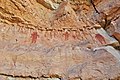 Rock Family pictograph site, Snake Gulch AZ.jpg 1,800 × 1,200; 2.36 MB
-
 Satellite image of the Grand Canyon.jpeg 1,219 × 947; 299 KB
-
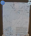 Toroweap Area map - Flickr - brewbooks.jpg 2,073 × 2,393; 1.62 MB


.jpg)
.jpg)
.jpg)


