Category:Kalkmolen
Jump to navigation
Jump to search
| Object location | | View all coordinates using: OpenStreetMap |
|---|
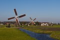
windmill in Hoogmade, Netherlands  | |||||
| Upload media | |||||
| Instance of | |||||
|---|---|---|---|---|---|
| Location | Hoogmade, South Holland, Netherlands | ||||
| Street address |
| ||||
| Has use |
| ||||
| Heritage designation |
| ||||
| Source of energy | |||||
 | |||||
|
This is a category about rijksmonument number 25702
|
| Address |
|
Media in category "Kalkmolen"
The following 5 files are in this category, out of 5 total.
-
 De Kalkmolen in opslag bij de molenmaker mrt 2009.jpg 1,500 × 1,000; 817 KB
-
 Hoogmade - Doesmolen met veldmuren voor voormalige Kalkmolen.jpg 1,800 × 1,200; 1.33 MB
-
 Hoogmade - Kalkmolen en Doesmolen 23 okt 2011.jpg 3,744 × 2,496; 1.63 MB
-
 Hoogmade - Kalkmolen m vier volle zeilen 23 okt 2011.jpg 2,504 × 3,755; 1.63 MB
-
 Hoogmade - Kalkmolen op zijn nieuwe plek.jpg 1,601 × 1,600; 1.34 MB


