Category:Kaituna River
Jump to navigation
Jump to search
river in the Bay of Plenty, New Zealand  | |||||
| Upload media | |||||
| Instance of | |||||
|---|---|---|---|---|---|
| Location | Bay of Plenty Region, New Zealand | ||||
| Length |
| ||||
| Mouth of the watercourse | |||||
| Tributary |
| ||||
 | |||||
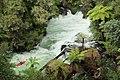
The Kaituna is a river of the North Island of New Zealand. A lesser-known 'Kaituna River' is located in Kahurangi National Park on the South Island.
Media in category "Kaituna River"
The following 18 files are in this category, out of 18 total.
-
 A Gentle Meander Down The Kaituna.jpg 4,288 × 2,848; 3.08 MB
-
 Bottom hole.jpg 3,000 × 2,000; 1.92 MB
-
 Bottom play hole.jpg 3,000 × 2,000; 1.95 MB
-
 Kaituna River (Kahurangi National Park).jpg 3,264 × 4,896; 6.27 MB
-
 Kaituna River Rafting 16.jpg 1,024 × 685; 521 KB
-
 Kaituna River Rafting 19.jpg 685 × 1,024; 149 KB
-
 Kaituna-River01.jpg 2,816 × 2,112; 1.16 MB
-
 Kaituna-River02.jpg 2,816 × 2,112; 1.57 MB
-
 Kayakers at Okere Falls (Kaituna River).jpg 4,896 × 3,264; 6.63 MB
-
 Large inflatable boat going down Tutea Falls (Kaituna River).jpg 4,896 × 3,264; 6.72 MB
-
 Okere Falls (Kaituna River).jpg 4,896 × 3,264; 6.01 MB
-
 Okere Falls, Kaituna River.jpg 2,592 × 3,872; 3.26 MB
-
 Okere falls.jpg 2,000 × 3,000; 1.8 MB
-
 Power station at Okere Falls, Rotorua District (21668786135).jpg 3,759 × 5,127; 2.07 MB
-
 The Weir.jpg 3,000 × 2,000; 1.73 MB
-
 Tutea Falls on the Kaituna River.jpg 3,264 × 4,896; 7.2 MB
-
 Tutea falls.jpg 3,000 × 2,000; 1.93 MB
-
 View from Kaituna Track across dense native bush and tree ferns.jpg 4,896 × 3,264; 6.18 MB


.jpg)


.jpg)
.jpg)
.jpg)


.jpg)


