Category:Kaiserweiher (Rosenheim)
Jump to navigation
Jump to search
| Object location | | View all coordinates using: OpenStreetMap |
|---|
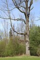
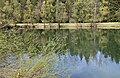
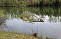
This is the category of the protected area listed at WDPA under the ID 396027
|
Wasserflächeː ca. 1,2 ha
Media in category "Kaiserweiher (Rosenheim)"
The following 14 files are in this category, out of 14 total.
-
 Am Kaiserweiher Kastenau Rosenheim-1.jpg 3,648 × 5,472; 6.71 MB
-
 Am Kaiserweiher Kastenau Rosenheim-2.jpg 4,915 × 3,485; 5.06 MB
-
 Am Kaiserweiher Kastenau Rosenheim-3.jpg 5,472 × 3,648; 5.44 MB
-
 Am Kaiserweiher Kastenau Rosenheim-4.jpg 5,445 × 3,360; 4.72 MB
-
 Am Kaiserweiher Kastenau Rosenheim-5.jpg 3,648 × 5,472; 5.68 MB
-
 Am Kaiserweiher Kastenau Rosenheim-6.jpg 5,385 × 3,475; 5.74 MB
-
 Kaiserweiher Kastenau Rosenheim-1.jpg 5,380 × 3,535; 3.95 MB
-
 Kaiserweiher Kastenau Rosenheim-2.jpg 5,472 × 3,648; 4.18 MB
-
 Kaiserweiher Kastenau Rosenheim-3.jpg 5,472 × 3,648; 4.36 MB
-
 Kaiserweiher Kastenau Rosenheim-4.jpg 5,472 × 3,648; 4.75 MB
-
 Kaiserweiher Kastenau Rosenheim-5.jpg 5,355 × 3,470; 4.53 MB
-
 Kaiserweiher Kastenau Rosenheim-6.jpg 5,385 × 3,530; 4.06 MB
-
 Kaiserweiher Kastenau Rosenheim-7.jpg 5,370 × 3,475; 3.74 MB
-
 Kaiserweiher Kastenau Rosenheim-8.jpg 5,375 × 3,500; 3.53 MB


