Category:Kaiserstraße 32 (Brühl, Rheinland)
Jump to navigation
Jump to search
| Object location | | View all coordinates using: OpenStreetMap |
|---|
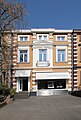
| This category shows a heritage building in Germany, located in the North Rhine-Westphalian city Brühl (Rheinland) (no. 134). |
Media in category "Kaiserstraße 32 (Brühl, Rheinland)"
This category contains only the following file.
-
 Brühl Kaiserstraße 32.JPG 3,456 × 5,100; 4.04 MB
