Category:Kaiserlicher Gottesacker (Steighäuli, Klingnau)
Jump to navigation
Jump to search
| Object location | | View all coordinates using: OpenStreetMap |
|---|
graveyard in Klingnau in the canton of Aargau, Switzerland  | |||||
| Upload media | |||||
| Instance of | |||||
|---|---|---|---|---|---|
| Part of | |||||
| Location | Klingnau, Zurzach District, Aargau, Switzerland | ||||
| Street address |
| ||||
| Heritage designation | |||||
| Inception |
| ||||
 | |||||
Media in category "Kaiserlicher Gottesacker (Steighäuli, Klingnau)"
The following 4 files are in this category, out of 4 total.
-
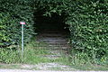 Klingnau Kaiserlicher Gottesacker Eingang.jpg 2,304 × 1,536; 2.51 MB
-
 Klingnau Kaiserlicher Gottesacker Inschrift.jpg 1,536 × 2,304; 1.62 MB
-
 Klingnau Kaiserlicher Gottesacker Kreuz.jpg 1,536 × 2,304; 2.22 MB
-
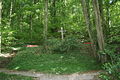 Klingnau Kaiserlicher Gottesacker Übersicht.jpg 2,304 × 1,536; 2.78 MB


