Category:Köppen-Geiger Climate Classification Maps for 1931–1960
Jump to navigation
Jump to search
Media in category "Köppen-Geiger Climate Classification Maps for 1931–1960"
The following 200 files are in this category, out of 485 total.
(previous page) (next page)-
 Koppen-Geiger Map v2 A 1931–1960.svg 1,401 × 928; 26.65 MB
-
 Koppen-Geiger Map v2 Af 1931–1960.svg 1,401 × 928; 26.61 MB
-
 Koppen-Geiger Map v2 AFG 1931–1960.svg 1,626 × 850; 1.06 MB
-
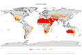
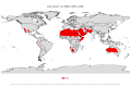
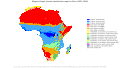 Koppen-Geiger Map v2 Africa 1931–1960.svg 1,506 × 850; 2.56 MB
-
 Koppen-Geiger Map v2 AGO 1931–1960.svg 1,381 × 850; 769 KB
-
 Koppen-Geiger Map v2 ALB 1931–1960.svg 1,275 × 850; 519 KB
-
 Koppen-Geiger Map v2 Am 1931–1960.svg 1,401 × 928; 26.62 MB
-
 Koppen-Geiger Map v2 ARE 1931–1960.svg 1,390 × 850; 1.07 MB
-
 Koppen-Geiger Map v2 ARG 1931–1960.svg 1,278 × 850; 1.6 MB
-
 Koppen-Geiger Map v2 ARG Buenos Aires 1931–1960.svg 1,378 × 850; 1.07 MB
-
 Koppen-Geiger Map v2 ARG Catamarca 1931–1960.svg 1,353 × 850; 518 KB
-
 Koppen-Geiger Map v2 ARG Chaco 1931–1960.svg 1,511 × 850; 636 KB
-
 Koppen-Geiger Map v2 ARG Chubut 1931–1960.svg 1,816 × 850; 1.03 MB
-
 Koppen-Geiger Map v2 ARG Corrientes 1931–1960.svg 1,464 × 850; 586 KB
-
 Koppen-Geiger Map v2 ARG Córdoba 1931–1960.svg 1,326 × 850; 447 KB
-
 Koppen-Geiger Map v2 ARG Entre Ríos 1931–1960.svg 1,321 × 850; 441 KB
-
 Koppen-Geiger Map v2 ARG Formosa 1931–1960.svg 1,438 × 850; 582 KB
-
 Koppen-Geiger Map v2 ARG Jujuy 1931–1960.svg 1,431 × 850; 591 KB
-
 Koppen-Geiger Map v2 ARG La Pampa 1931–1960.svg 1,455 × 850; 571 KB
-
 Koppen-Geiger Map v2 ARG La Rioja 1931–1960.svg 1,399 × 850; 544 KB
-
 Koppen-Geiger Map v2 ARG Mendoza 1931–1960.svg 1,326 × 850; 506 KB
-
 Koppen-Geiger Map v2 ARG Misiones 1931–1960.svg 1,400 × 850; 508 KB
-
 Koppen-Geiger Map v2 ARG Neuquén 1931–1960.svg 1,349 × 850; 545 KB
-
 Koppen-Geiger Map v2 ARG Río Negro 1931–1960.svg 1,816 × 850; 854 KB
-
 Koppen-Geiger Map v2 ARG Salta 1931–1960.svg 1,551 × 850; 757 KB
-
 Koppen-Geiger Map v2 ARG San Juan 1931–1960.svg 1,368 × 850; 532 KB
-
 Koppen-Geiger Map v2 ARG San Luis 1931–1960.svg 1,280 × 850; 388 KB
-
 Koppen-Geiger Map v2 ARG Santa Cruz 1931–1960.svg 1,505 × 850; 860 KB
-
 Koppen-Geiger Map v2 ARG Santa Fe 1931–1960.svg 1,270 × 850; 377 KB
-
 Koppen-Geiger Map v2 ARG Santiago del Estero 1931–1960.svg 1,306 × 850; 413 KB
-
 Koppen-Geiger Map v2 ARG Tierra del Fuego 1931–1960.svg 1,804 × 850; 1.18 MB
-
 Koppen-Geiger Map v2 ARG Tucumán 1931–1960.svg 1,358 × 850; 483 KB
-
 Koppen-Geiger Map v2 ARM 1931–1960.svg 1,526 × 850; 668 KB
-
 Koppen-Geiger Map v2 Asia 1931–1960.svg 1,803 × 850; 6.06 MB
-
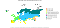
 Koppen-Geiger Map v2 Asiatic Russia 1931–1960.svg 1,780 × 850; 2.97 MB
-
 Koppen-Geiger Map v2 AUS 1931–1960.svg 1,428 × 850; 5.11 MB
-
 Koppen-Geiger Map v2 AUS New South Wales 1931–1960.svg 1,816 × 850; 1.29 MB
-
 Koppen-Geiger Map v2 AUS Northern Territory 1931–1960.svg 1,184 × 850; 759 KB
-
 Koppen-Geiger Map v2 AUS Queensland 1931–1960.svg 1,345 × 850; 1.59 MB
-
 Koppen-Geiger Map v2 AUS South Australia 1931–1960.svg 1,424 × 850; 863 KB
-
 Koppen-Geiger Map v2 AUS Victoria 1931–1960.svg 1,771 × 850; 1.17 MB
-
 Koppen-Geiger Map v2 AUS Western Australia 1931–1960.svg 1,323 × 850; 2.1 MB
-
 Koppen-Geiger Map v2 Australia–New Zealand 1931–1960.svg 1,664 × 850; 3.04 MB
-
 Koppen-Geiger Map v2 AUT 1931–1960.svg 1,769 × 850; 667 KB
-
 Koppen-Geiger Map v2 Aw 1931–1960.svg 1,401 × 928; 26.63 MB
-
 Koppen-Geiger Map v2 B 1931–1960.svg 1,401 × 928; 26.68 MB
-
 Koppen-Geiger Map v2 BDI 1931–1960.svg 1,363 × 850; 567 KB
-
 Koppen-Geiger Map v2 BEL 1931–1960.svg 1,816 × 850; 817 KB
-
 Koppen-Geiger Map v2 BEN 1931–1960.svg 1,184 × 850; 353 KB
-
 Koppen-Geiger Map v2 BFA 1931–1960.svg 1,388 × 850; 705 KB
-
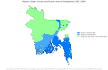 Koppen-Geiger Map v2 BGD 1931–1960.svg 1,310 × 850; 1.15 MB
-
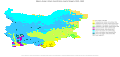 Koppen-Geiger Map v2 BGR 1931–1960.svg 1,816 × 850; 917 KB
-
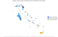 Koppen-Geiger Map v2 BHS 1931–1960.svg 1,326 × 850; 2.53 MB
-
 Koppen-Geiger Map v2 BIH 1931–1960.svg 1,578 × 850; 717 KB
-
 Koppen-Geiger Map v2 BLR 1931–1960.svg 1,769 × 850; 829 KB
-
 Koppen-Geiger Map v2 BLZ 1931–1960.svg 1,304 × 850; 965 KB
-
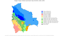 Koppen-Geiger Map v2 BOL 1931–1960.svg 1,398 × 850; 819 KB
-
 Koppen-Geiger Map v2 BRA 1931–1960.svg 1,480 × 850; 2.48 MB
-
 Koppen-Geiger Map v2 BRA Acre 1931–1960.svg 1,640 × 850; 848 KB
-
 Koppen-Geiger Map v2 BRA Alagoas 1931–1960.svg 1,640 × 850; 879 KB
-
 Koppen-Geiger Map v2 BRA Amapá 1931–1960.svg 1,206 × 850; 579 KB
-
 Koppen-Geiger Map v2 BRA Bahia 1931–1960.svg 1,406 × 850; 932 KB
-
 Koppen-Geiger Map v2 BRA Ceará 1931–1960.svg 1,185 × 850; 546 KB
-
 Koppen-Geiger Map v2 BRA Goiás 1931–1960.svg 1,415 × 850; 607 KB
-
 Koppen-Geiger Map v2 BRA Maranhão 1931–1960.svg 1,184 × 850; 833 KB
-
 Koppen-Geiger Map v2 BRA Mato Grosso 1931–1960.svg 1,426 × 850; 631 KB
-
 Koppen-Geiger Map v2 BRA Mato Grosso do Sul 1931–1960.svg 1,425 × 850; 617 KB
-
 Koppen-Geiger Map v2 BRA Minas Gerais 1931–1960.svg 1,526 × 850; 905 KB
-
 Koppen-Geiger Map v2 BRA Paraná 1931–1960.svg 1,651 × 850; 949 KB
-
 Koppen-Geiger Map v2 BRA Pará 1931–1960.svg 1,260 × 850; 836 KB
-
 Koppen-Geiger Map v2 BRA Pernambuco 1931–1960.svg 1,804 × 850; 653 KB
-
 Koppen-Geiger Map v2 BRA Piauí 1931–1960.svg 1,184 × 850; 446 KB
-
 Koppen-Geiger Map v2 BRA Rio de Janeiro 1931–1960.svg 1,609 × 850; 1.22 MB
-
 Koppen-Geiger Map v2 BRA Rio Grande do Sul 1931–1960.svg 1,491 × 850; 842 KB
-
 Koppen-Geiger Map v2 BRA Rondônia 1931–1960.svg 1,340 × 850; 660 KB
-
 Koppen-Geiger Map v2 BRA Roraima 1931–1960.svg 1,378 × 850; 520 KB
-
 Koppen-Geiger Map v2 BRA Sergipe 1931–1960.svg 1,194 × 850; 537 KB
-
 Koppen-Geiger Map v2 BRA São Paulo 1931–1960.svg 1,725 × 850; 1.08 MB
-
 Koppen-Geiger Map v2 BRA Tocantins 1931–1960.svg 1,184 × 850; 412 KB
-
 Koppen-Geiger Map v2 BSh 1931–1960.svg 1,401 × 928; 26.62 MB
-
 Koppen-Geiger Map v2 BSk 1931–1960.svg 1,401 × 928; 26.64 MB
-
 Koppen-Geiger Map v2 BTN 1931–1960.svg 1,794 × 850; 768 KB
-
 Koppen-Geiger Map v2 BWA 1931–1960.svg 1,254 × 850; 600 KB
-
 Koppen-Geiger Map v2 BWh 1931–1960.svg 1,401 × 928; 26.62 MB
-
 Koppen-Geiger Map v2 BWk 1931–1960.svg 1,401 × 928; 26.62 MB
-
 Koppen-Geiger Map v2 C 1931–1960.svg 1,401 × 928; 26.69 MB
-
 Koppen-Geiger Map v2 CAF 1931–1960.svg 1,419 × 850; 793 KB
-
 Koppen-Geiger Map v2 CAN 1931–1960.svg 1,816 × 850; 23.29 MB
-
 Koppen-Geiger Map v2 CAN Alberta 1931–1960.svg 1,345 × 850; 606 KB
-
 Koppen-Geiger Map v2 CAN British Columbia 1931–1960.svg 1,816 × 850; 4.13 MB
-
 Koppen-Geiger Map v2 CAN Manitoba 1931–1960.svg 1,443 × 850; 745 KB
-
 Koppen-Geiger Map v2 CAN New Brunswick 1931–1960.svg 1,543 × 850; 1.07 MB
-
 Koppen-Geiger Map v2 CAN Newfoundland and Labrador 1931–1960.svg 1,363 × 850; 4 MB
-
 Koppen-Geiger Map v2 CAN Northwest Territories 1931–1960.svg 1,769 × 850; 2.68 MB
-
 Koppen-Geiger Map v2 CAN Nova Scotia 1931–1960.svg 1,736 × 850; 2.18 MB
-
 Koppen-Geiger Map v2 CAN Nunavut 1931–1960.svg 1,780 × 850; 11.04 MB
-
 Koppen-Geiger Map v2 CAN Ontario 1931–1960.svg 1,508 × 850; 972 KB
-
 Koppen-Geiger Map v2 CAN Prince Edward Island 1931–1960.svg 1,769 × 850; 1.05 MB
-
 Koppen-Geiger Map v2 CAN Québec 1931–1960.svg 1,475 × 850; 5.14 MB
-
 Koppen-Geiger Map v2 CAN Saskatchewan 1931–1960.svg 1,300 × 850; 484 KB
-
 Koppen-Geiger Map v2 CAN Yukon 1931–1960.svg 1,593 × 850; 1.05 MB
-
 Koppen-Geiger Map v2 Caribbean 1931–1960.svg 1,610 × 850; 1.57 MB
-
 Koppen-Geiger Map v2 Central America 1931–1960.svg 1,683 × 850; 2.74 MB
-
 Koppen-Geiger Map v2 Central Asia 1931–1960.svg 1,786 × 850; 1.77 MB
-
 Koppen-Geiger Map v2 Cfa 1931–1960.svg 1,401 × 928; 26.61 MB
-
 Koppen-Geiger Map v2 Cfb 1931–1960.svg 1,401 × 928; 26.62 MB
-
 Koppen-Geiger Map v2 Cfc 1931–1960.svg 1,401 × 928; 26.6 MB
-
 Koppen-Geiger Map v2 CHE 1931–1960.svg 1,816 × 850; 786 KB
-
 Koppen-Geiger Map v2 CHL 1931–1960.svg 1,468 × 850; 8.27 MB
-
 Koppen-Geiger Map v2 CHN 1931–1960.svg 1,763 × 850; 5.2 MB
-
 Koppen-Geiger Map v2 CHN Anhui 1931–1960.svg 1,393 × 850; 567 KB
-
 Koppen-Geiger Map v2 CHN Beijing 1931–1960.svg 1,458 × 850; 635 KB
-
 Koppen-Geiger Map v2 CHN Chongqing 1931–1960.svg 1,500 × 850; 696 KB
-
 Koppen-Geiger Map v2 CHN Fujian 1931–1960.svg 1,441 × 850; 1.47 MB
-
 Koppen-Geiger Map v2 CHN Gansu 1931–1960.svg 1,628 × 850; 955 KB
-
 Koppen-Geiger Map v2 CHN Guangdong 1931–1960.svg 1,580 × 850; 1.48 MB
-
 Koppen-Geiger Map v2 CHN Guangxi 1931–1960.svg 1,559 × 850; 969 KB
-
 Koppen-Geiger Map v2 CHN Guizhou 1931–1960.svg 1,531 × 850; 745 KB
-
 Koppen-Geiger Map v2 CHN Hainan 1931–1960.svg 1,519 × 850; 1,017 KB
-
 Koppen-Geiger Map v2 CHN Hebei 1931–1960.svg 1,346 × 850; 677 KB
-
 Koppen-Geiger Map v2 CHN Heilongjiang 1931–1960.svg 1,474 × 850; 813 KB
-
 Koppen-Geiger Map v2 CHN Henan 1931–1960.svg 1,499 × 850; 706 KB
-
 Koppen-Geiger Map v2 CHN Hubei 1931–1960.svg 1,816 × 850; 955 KB
-
 Koppen-Geiger Map v2 CHN Hunan 1931–1960.svg 1,424 × 850; 606 KB
-
 Koppen-Geiger Map v2 CHN Jiangsu 1931–1960.svg 1,505 × 850; 800 KB
-
 Koppen-Geiger Map v2 CHN Jiangxi 1931–1960.svg 1,381 × 850; 529 KB
-
 Koppen-Geiger Map v2 CHN Jilin 1931–1960.svg 1,730 × 850; 907 KB
-
 Koppen-Geiger Map v2 CHN Liaoning 1931–1960.svg 1,525 × 850; 1.18 MB
-
 Koppen-Geiger Map v2 CHN Nei Mongol 1931–1960.svg 1,746 × 850; 1.11 MB
-
 Koppen-Geiger Map v2 CHN Ningxia Hui 1931–1960.svg 1,289 × 850; 498 KB
-
 Koppen-Geiger Map v2 CHN Qinghai 1931–1960.svg 1,709 × 850; 1,010 KB
-
 Koppen-Geiger Map v2 CHN Shaanxi 1931–1960.svg 1,306 × 850; 590 KB
-
 Koppen-Geiger Map v2 CHN Shandong 1931–1960.svg 1,776 × 850; 1.17 MB
-
 Koppen-Geiger Map v2 CHN Shanghai 1931–1960.svg 1,588 × 850; 1.32 MB
-
 Koppen-Geiger Map v2 CHN Shanxi 1931–1960.svg 1,276 × 850; 507 KB
-
 Koppen-Geiger Map v2 CHN Sichuan 1931–1960.svg 1,530 × 850; 1 MB
-
 Koppen-Geiger Map v2 CHN Tianjin 1931–1960.svg 1,289 × 850; 476 KB
-
 Koppen-Geiger Map v2 CHN Xinjiang Uygur 1931–1960.svg 1,580 × 850; 1.08 MB
-
 Koppen-Geiger Map v2 CHN Xizang 1931–1960.svg 1,794 × 850; 1.19 MB
-
 Koppen-Geiger Map v2 CHN Yunnan 1931–1960.svg 1,428 × 850; 815 KB
-
 Koppen-Geiger Map v2 CHN Zhejiang 1931–1960.svg 1,501 × 850; 2.03 MB
-
 Koppen-Geiger Map v2 CIV 1931–1960.svg 1,234 × 850; 600 KB
-
 Koppen-Geiger Map v2 CMR 1931–1960.svg 1,306 × 850; 533 KB
-
 Koppen-Geiger Map v2 COD 1931–1960.svg 1,430 × 850; 824 KB
-
 Koppen-Geiger Map v2 COG 1931–1960.svg 1,196 × 850; 547 KB
-
 Koppen-Geiger Map v2 COL 1931–1960.svg 1,333 × 850; 989 KB
-
 Koppen-Geiger Map v2 CRI 1931–1960.svg 1,351 × 850; 731 KB
-
 Koppen-Geiger Map v2 Csa 1931–1960.svg 1,401 × 928; 26.61 MB
-
 Koppen-Geiger Map v2 Csb 1931–1960.svg 1,401 × 928; 26.61 MB
-
 Koppen-Geiger Map v2 Csc 1931–1960.svg 1,401 × 928; 26.6 MB
-
 Koppen-Geiger Map v2 CUB 1931–1960.svg 1,816 × 850; 3 MB
-
 Koppen-Geiger Map v2 Cwa 1931–1960.svg 1,401 × 928; 26.62 MB
-
 Koppen-Geiger Map v2 Cwb 1931–1960.svg 1,401 × 928; 26.62 MB
-
 Koppen-Geiger Map v2 Cwc 1931–1960.svg 1,401 × 928; 26.6 MB
-
 Koppen-Geiger Map v2 CYP 1931–1960.svg 1,804 × 850; 691 KB
-
 Koppen-Geiger Map v2 CZE 1931–1960.svg 1,769 × 850; 687 KB
-
 Koppen-Geiger Map v2 D 1931–1960.svg 1,401 × 928; 26.72 MB
-
 Koppen-Geiger Map v2 DEU 1931–1960.svg 1,488 × 850; 1.1 MB
-
 Koppen-Geiger Map v2 Dfa 1931–1960.svg 1,401 × 928; 26.61 MB
-
 Koppen-Geiger Map v2 Dfb 1931–1960.svg 1,401 × 928; 26.63 MB
-
 Koppen-Geiger Map v2 Dfc 1931–1960.svg 1,401 × 928; 26.64 MB
-
 Koppen-Geiger Map v2 Dfd 1931–1960.svg 1,401 × 928; 26.6 MB
-
 Koppen-Geiger Map v2 DJI 1931–1960.svg 1,221 × 850; 585 KB
-
 Koppen-Geiger Map v2 DNK 1931–1960.svg 1,816 × 850; 1.99 MB
-
 Koppen-Geiger Map v2 DOM 1931–1960.svg 1,599 × 850; 1.11 MB
-
 Koppen-Geiger Map v2 Dsa 1931–1960.svg 1,401 × 928; 26.6 MB
-
 Koppen-Geiger Map v2 Dsb 1931–1960.svg 1,401 × 928; 26.61 MB
-
 Koppen-Geiger Map v2 Dsc 1931–1960.svg 1,401 × 928; 26.62 MB
-
 Koppen-Geiger Map v2 Dsd 1931–1960.svg 1,401 × 928; 26.6 MB
-
 Koppen-Geiger Map v2 Dwa 1931–1960.svg 1,401 × 928; 26.6 MB
-
 Koppen-Geiger Map v2 Dwb 1931–1960.svg 1,401 × 928; 26.61 MB
-
 Koppen-Geiger Map v2 Dwc 1931–1960.svg 1,401 × 928; 26.62 MB
-
 Koppen-Geiger Map v2 Dwd 1931–1960.svg 1,401 × 928; 26.6 MB
-
 Koppen-Geiger Map v2 DZA 1931–1960.svg 1,463 × 850; 728 KB
-
 Koppen-Geiger Map v2 E 1931–1960.svg 1,401 × 928; 26.65 MB
-
 Koppen-Geiger Map v2 Eastern Africa 1931–1960.svg 1,399 × 850; 2.55 MB
-
 Koppen-Geiger Map v2 Eastern Asia 1931–1960.svg 1,816 × 850; 4.86 MB
-
 Koppen-Geiger Map v2 Eastern Europe 1931–1960.svg 1,620 × 850; 2.73 MB
-
 Koppen-Geiger Map v2 ECU 1931–1960.svg 1,816 × 850; 975 KB
-
 Koppen-Geiger Map v2 EF 1931–1960.svg 1,401 × 928; 26.61 MB
-
 Koppen-Geiger Map v2 EGY 1931–1960.svg 1,303 × 850; 824 KB
-
 Koppen-Geiger Map v2 ERI 1931–1960.svg 1,490 × 850; 1.12 MB
-
 Koppen-Geiger Map v2 ESH 1931–1960.svg 1,318 × 850; 684 KB
-
 Koppen-Geiger Map v2 ESP 1931–1960.svg 1,563 × 850; 1.27 MB
-
 Koppen-Geiger Map v2 EST 1931–1960.svg 1,769 × 850; 2.8 MB
-
 Koppen-Geiger Map v2 ET 1931–1960.svg 1,401 × 928; 26.65 MB
-
 Koppen-Geiger Map v2 ETH 1931–1960.svg 1,533 × 850; 954 KB
-
 Koppen-Geiger Map v2 Europe 1931–1960.svg 1,816 × 850; 6.11 MB
-
 Koppen-Geiger Map v2 European Russia 1931–1960.svg 1,500 × 850; 2 MB
-
 Koppen-Geiger Map v2 FIN 1931–1960.svg 1,400 × 850; 3.19 MB
-
 Koppen-Geiger Map v2 FLK 1931–1960.svg 1,804 × 850; 3.23 MB
-
 Koppen-Geiger Map v2 FRA 1931–1960.svg 1,608 × 850; 1.67 MB
-
 Koppen-Geiger Map v2 GAB 1931–1960.svg 1,221 × 850; 743 KB
-
 Koppen-Geiger Map v2 GBR 1931–1960.svg 1,539 × 850; 2.48 MB
-
 Koppen-Geiger Map v2 GEO 1931–1960.svg 1,816 × 850; 739 KB
-
 Koppen-Geiger Map v2 GHA 1931–1960.svg 1,184 × 850; 521 KB
-
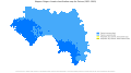 Koppen-Geiger Map v2 GIN 1931–1960.svg 1,538 × 850; 944 KB
-
 Koppen-Geiger Map v2 GMB 1931–1960.svg 1,640 × 850; 460 KB
-
 Koppen-Geiger Map v2 GNB 1931–1960.svg 1,559 × 850; 1.64 MB
-
 Koppen-Geiger Map v2 GNQ 1931–1960.svg 1,456 × 850; 576 KB


