Category:Königsteiner Straße 2 (Oberjosbach)
Jump to navigation
Jump to search
| Object location | | View all coordinates using: OpenStreetMap |
|---|
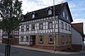
This is the category of the Hessian Kulturdenkmal (cultural monument) with the ID 14065 (Wikidata)
|
Cultural heritage monument in Oberjosbach, Hesse, Germany  | |||||
| Upload media | |||||
| Instance of | |||||
|---|---|---|---|---|---|
| Location | Oberjosbach, Niedernhausen, Rheingau-Taunus-Kreis, Darmstadt Government Region, Hesse, Germany | ||||
| Street address |
| ||||
| Heritage designation | |||||
 | |||||
Media in category "Königsteiner Straße 2 (Oberjosbach)"
The following 3 files are in this category, out of 3 total.
-
 KönigsteinerStr2.jpg 4,240 × 2,832; 3.87 MB
-
 Oberjosbach, Königsteiner Straße 2 (1).jpg 4,816 × 3,744; 13.16 MB
-
 Oberjosbach, Königsteiner Straße 2.jpg 4,856 × 3,872; 12.97 MB

.jpg)