Category:Jungbornstraße (Glienicke/Nordbahn)
Jump to navigation
Jump to search
Deutsch: Ansichten der "Jungbornstraße" in Glienicke/Nordbahn , Gemeinde Glienicke/Nordbahn , Landkreis Oberhavel , Land Brandenburg, Deutschland.
English: Pictures of the street "Jungbornstraße" in Glienicke/Nordbahn , Glienicke/Nordbahn municipality , Oberhavel district, Brandenburg state, Germany.
Français : Photos de la rue "Jungbornstraße" à Glienicke/Nordbahn , commune de Glienicke/Nordbahn , arrondissement de Oberhavel , état fédéral de Brandebourg, Allemagne
Español: Vistas de la calle "Jungbornstraße" en Glienicke/Nordbahn , municipio de Glienicke/Nordbahn , distrito de Oberhavel , estado federado de Brandeburgo, Alemania
| Object location | | View all coordinates using: OpenStreetMap |
|---|
Adress
Jungbornstraße, 16548 Glienicke/Nordbahn
street in Glienicke/Nordbahn, Germany  | |||||
| Upload media | |||||
| Instance of | |||||
|---|---|---|---|---|---|
| Location | Glienicke/Nordbahn, Oberhavel District, Brandenburg, Germany | ||||
| Connects with | |||||
| Length |
| ||||
 | |||||
Media in category "Jungbornstraße (Glienicke/Nordbahn)"
The following 5 files are in this category, out of 5 total.
-
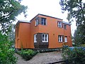
 Jungbornstraße 17 Glienicke-Nordbahn 2021 NE.jpg 4,032 × 3,024; 3.71 MB
-
 Jungbornstraße 17 Glienicke-Nordbahn 2021 NNE.jpg 4,032 × 3,024; 3.66 MB
-
 Jungbornstraße 22 Glienicke-Nordbahn 2014 NE.jpg 3,264 × 2,448; 2.98 MB
-
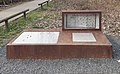 Denkmal Jungbornstr 29 (Glienicke) Grenzsperre.jpg 2,588 × 1,593; 2.62 MB
-
 Gedenktafel Jungbornstr 29 (Glienicke) Grenzsperre.jpg 1,597 × 1,766; 1.07 MB


_Grenzsperre.jpg)
_Grenzsperre.jpg)