Category:Jufferenstraat 12, Elburg
Jump to navigation
Jump to search
| Object location | | View all coordinates using: OpenStreetMap |
|---|
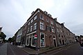
building in Elburg, Netherlands  | |||||
| Upload media | |||||
| Instance of | |||||
|---|---|---|---|---|---|
| Location | Elburg, Gelderland, Netherlands | ||||
| Street address |
| ||||
| Located on street |
| ||||
| Heritage designation |
| ||||
 | |||||
|
This is a category about rijksmonument number 14775
|
| Address |
|
Media in category "Jufferenstraat 12, Elburg"
The following 6 files are in this category, out of 6 total.
-
 Achtergevel - Elburg - 20069021 - RCE.jpg 3,078 × 3,084; 2.79 MB
-
 Elburg, Netherlands - panoramio (103).jpg 2,048 × 1,155; 501 KB
-
 Elburg, Netherlands - panoramio (72).jpg 4,896 × 3,264; 2.3 MB
-
 Elburg- Jufferenstraat 12.JPG 3,840 × 2,160; 2.57 MB
-
 Exterieur VOORGEVELS - Elburg - 20339676 - RCE.jpg 953 × 1,200; 268 KB
-
 Vesting Elburg - Jufferenstraat - Ledige Stede - Museum Elburg - Winter February 2021.jpg 3,976 × 2,652; 5.61 MB

.jpg)
.jpg)

