Category:John of Nepomuk chapel, Enzersfeld
Jump to navigation
Jump to search
| Object location | | View all coordinates using: OpenStreetMap |
|---|
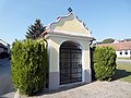
building in Enzersfeld, Austria  | |||||
| Upload media | |||||
| Instance of | |||||
|---|---|---|---|---|---|
| Location | Enzersfeld, Korneuburg District, Lower Austria, Austria | ||||
| Heritage designation | |||||
 | |||||
| This category shows the protected monument with the number 19542 in Austria. (Commons, de, Wikidata) |
Deutsch: Nepomuk-Wegkapelle in der niederösterreichischen Marktgemeinde Enzersfeld im Weinviertel. Der nachbarocke Bau mit geschwungenem Giebel wurde Mitte des 19. Jahrhunderts errichtet. Die Nepomukstatue ist mit 1856 datiert.
Media in category "John of Nepomuk chapel, Enzersfeld"
The following 3 files are in this category, out of 3 total.
-
 Enzersfeld - Nepomukkapelle, Statue.JPG 2,784 × 3,937; 7.09 MB
-
 Enzersfeld - Nepomukkapelle.JPG 4,331 × 3,063; 11.99 MB
-
 Enzersfeld-Wegkapelle.jpg 3,648 × 2,736; 2.8 MB

