Category:John G. Young Landing
Jump to navigation
Jump to search
| Object location | | View all coordinates using: OpenStreetMap |
|---|
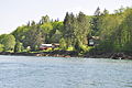
English: A small park on the Skagit River, reached by Faber Rd. off of Washington State Route 20.
Media in category "John G. Young Landing"
The following 5 files are in this category, out of 5 total.
-
 John G. Young landing on Skagit River - pano 01.jpg 8,856 × 2,534; 7.53 MB
-
 John G. Young landing on Skagit River - sign.jpg 4,288 × 2,848; 6.32 MB
-
 John G. Young landing on Skagit River - view 01.jpg 4,288 × 2,848; 6.44 MB
-
 John G. Young landing on Skagit River - view 02.jpg 4,288 × 2,848; 6.13 MB
-
 John G. Young landing on Skagit River - water 01.jpg 4,288 × 2,848; 6.58 MB


