Category:Johannes de Doperkerk (Oosteind)
Jump to navigation
Jump to search
| Object location | | View all coordinates using: OpenStreetMap |
|---|
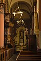
Nederlands: Afbeeldingen van de Johannes de Doperkerk (Oosteind), Provincialeweg 86, 4909 AL Oosteind. Gelegen in Oosteind behorende tot de gemeente Oosterhout in de provincie Noord-Brabant in het zuiden van Nederland. Het is een rijksmonument
|
This is a category about rijksmonument number 31685
|
church building in Oosterhout, Netherlands  | |||||
| Upload media | |||||
| Instance of | |||||
|---|---|---|---|---|---|
| Location | Oosteind, Oosterhout, North Brabant, Netherlands | ||||
| Street address |
| ||||
| Located on street |
| ||||
| Architect |
| ||||
| Heritage designation |
| ||||
| Religion or worldview | |||||
 | |||||
Subcategories
This category has the following 3 subcategories, out of 3 total.
Media in category "Johannes de Doperkerk (Oosteind)"
The following 8 files are in this category, out of 8 total.
-
 De Johannes de Doperkerk te Oosteind.jpg 3,710 × 5,395; 16.31 MB
-
 De Johannes de Doperkerk te Oosteind2.jpg 3,915 × 5,803; 19.64 MB
-
 Exterieur kerk - Oosteind - 20173792 - RCE.jpg 944 × 1,200; 225 KB
-
 Exterieur kerk - Oosteind - 20173793 - RCE.jpg 1,200 × 950; 240 KB
-
 Johannes de Doperkerk te Oostend.jpg 7,077 × 5,457; 29.15 MB
-
 Oosteind H. Johannes de Doperkerk (foto 03-06-2017).1 (f2).jpg 6,000 × 4,000; 6.24 MB
-
 Oosteind H. Johannes de Doperkerk (foto 03-06-2017).2 (f2).jpg 4,000 × 6,000; 6.8 MB
-
 P1040584Sint Joannes de Doper kerk.JPG 2,448 × 3,264; 3.1 MB


.1_(f2).jpg)
.2_(f2).jpg)