Category:Janskerkhof 24, Utrecht
Jump to navigation
Jump to search
| Object location | | View all coordinates using: OpenStreetMap |
|---|
 | |||||
| Upload media | |||||
| Instance of |
| ||||
|---|---|---|---|---|---|
| Location | Utrecht, Netherlands | ||||
| Street address |
| ||||
| Heritage designation |
| ||||
 | |||||
|
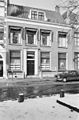
This is a category about rijksmonument number 36168
|
| Address |
|
Media in category "Janskerkhof 24, Utrecht"
The following 5 files are in this category, out of 5 total.
-
 Exterieur VOORGEVEL - Utrecht - 20306213 - RCE.jpg 788 × 1,200; 237 KB
-
 Janskerkhof 24.JPG 1,944 × 2,592; 741 KB
-
 Overzicht - Utrecht - 20235816 - RCE.jpg 1,200 × 948; 315 KB
-
 Voorgevels - Utrecht - 20235819 - RCE.jpg 1,200 × 952; 272 KB
-
 Voorgevels - Utrecht - 20235820 - RCE.jpg 1,200 × 820; 183 KB


