Category:Jagerskade 13, Utrecht
Jump to navigation
Jump to search
| Object location | | View all coordinates using: OpenStreetMap |
|---|
house in Utrecht, Netherlands  | |||||
| Upload media | |||||
| Instance of | |||||
|---|---|---|---|---|---|
| Location | Utrecht, Netherlands | ||||
| Street address |
| ||||
| Located on street | |||||
| Heritage designation |
| ||||
 | |||||
|
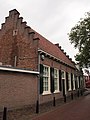
This is a category about rijksmonument number 450429
|
| Address |
|
Media in category "Jagerskade 13, Utrecht"
The following 5 files are in this category, out of 5 total.
-
 Overzicht - Utrecht - 20235749 - RCE.jpg 1,197 × 1,200; 442 KB
-
 Rechter zij- en achtergevel - Utrecht - 20235751 - RCE.jpg 1,195 × 1,200; 379 KB
-
 Rijksmonument450429.JPG 1,920 × 2,560; 1.08 MB
-
 Voor- en linker zijgevel - Utrecht - 20235750 - RCE.jpg 1,200 × 1,200; 429 KB
-
 Voor- en linker zijgevel - Utrecht - 20235911 - RCE.jpg 1,200 × 962; 250 KB


