Category:Jüdischer Friedhof Lathen
Jump to navigation
Jump to search
| Object location | | View all coordinates using: OpenStreetMap |
|---|
 | |||||
| Upload media | |||||
| Instance of | |||||
|---|---|---|---|---|---|
| Location | Lathen, Emsland, Lower Saxony, Germany | ||||
 | |||||
Subcategories
This category has only the following subcategory.
G
Media in category "Jüdischer Friedhof Lathen"
The following 17 files are in this category, out of 17 total.
-
 Lathen - Martin-Luther-Straße - Stephanus-Friedhof + Jüdischer Friedhof 01 ies.jpg 5,616 × 3,744; 27.05 MB
-
 Lathen - Melstruper Straße - Jüdischer Friedhof + Erna de Vries 01 ies.jpg 5,616 × 3,744; 32.2 MB
-
 Lathen - Melstruper Straße - Jüdischer Friedhof + Erna de Vries 02 ies.jpg 5,616 × 3,744; 28.05 MB
-
 Lathen - Melstruper Straße - Jüdischer Friedhof + Erna de Vries 03 ies.jpg 5,616 × 3,744; 27.03 MB
-
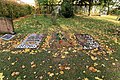
 Lathen - Melstruper Straße - Jüdischer Friedhof 01 ies.jpg 5,616 × 3,744; 21.63 MB
-
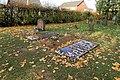
 Lathen - Melstruper Straße - Jüdischer Friedhof 02 ies.jpg 5,616 × 3,744; 28.72 MB
-
 Lathen - Melstruper Straße - Jüdischer Friedhof 03 ies.jpg 5,616 × 3,744; 24.49 MB
-
 Lathen - Melstruper Straße - Jüdischer Friedhof 04 ies.jpg 3,744 × 5,616; 23.62 MB
-
 Lathen - Melstruper Straße - Jüdischer Friedhof 05 ies.jpg 3,745 × 5,616; 24.51 MB
-
 Lathen - Melstruper Straße - Jüdischer Friedhof 06 ies.jpg 3,744 × 5,616; 24.76 MB
-
 Lathen - Melstruper Straße - Jüdischer Friedhof 07 ies.jpg 5,616 × 3,744; 29.26 MB
-
 Lathen - Melstruper Straße - Jüdischer Friedhof 08 ies.jpg 3,744 × 5,616; 24.98 MB
-
 Lathen - Melstruper Straße - Jüdischer Friedhof 09 ies.jpg 5,616 × 3,744; 25.71 MB
-
 Lathen - Melstruper Straße - Jüdischer Friedhof 10 ies.jpg 3,744 × 5,616; 22.73 MB
-
 Lathen - Melstruper Straße - Jüdischer Friedhof 11 ies.jpg 3,744 × 5,616; 21.21 MB
-
 Lathen - Melstruper Straße - Jüdischer Friedhof 12 ies.jpg 3,744 × 5,616; 21.13 MB
-
 Lathen - Melstruper Straße - Jüdischer Friedhof 13 ies.jpg 5,616 × 3,744; 22.06 MB


