Category:It-Turretta (Santa Venera)
Jump to navigation
Jump to search
| Object location | | View all coordinates using: OpenStreetMap |
|---|
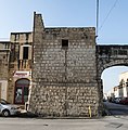
English: It-Turretta (the turret) is a tower in Santa Venera marking the end of the arches of the Wignacourt Aqueduct.
Media in category "It-Turretta (Santa Venera)"
The following 10 files are in this category, out of 10 total.
-
 Guard Tower St Venera.jpeg 1,936 × 2,592; 1.19 MB
-
 It-Turretta, Santa Venera 001.jpg 6,000 × 6,111; 19.98 MB
-
 Malta - Santa Venera - Triq il-Kbira San Guzepp + aqueduct + council 01 ies.jpg 5,616 × 3,744; 15.17 MB
-
 Malta - Santa Venera - Triq il-Kbira San Guzepp + aqueduct + council 02 ies.jpg 5,616 × 3,744; 11.94 MB
-
 Santa Venera feast 12.jpg 2,592 × 1,936; 919 KB
-
 Santa Venera feast 13.jpg 2,592 × 1,936; 1,012 KB
-
 Tower of St. Joseph.jpeg 1,936 × 2,592; 1.53 MB
-
 Towers of the Aqueduct 01.jpg 2,592 × 1,936; 884 KB
-
 Towers of the Aqueduct 02.jpg 1,936 × 2,592; 1,022 KB
-
 Triq il-Kbira San Ġużepp, Santa Venera, Malta - panoramio (15).jpg 2,624 × 1,968; 2.02 MB


.jpg)