Category:Isle of Wight Coastal Path
Jump to navigation
Jump to search
Long-distance footpath on the Isle of Wight, England | |||||
| Upload media | |||||
| Instance of |
| ||||
|---|---|---|---|---|---|
| Location | Isle of Wight, South East England, England | ||||
| Length |
| ||||
 | |||||

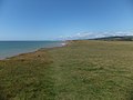
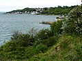
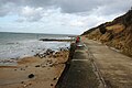
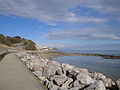
English: The Isle of Wight Coastal Path is a circular public footpath around the coast of the Isle of Wight.
Subcategories
This category has only the following subcategory.
Media in category "Isle of Wight Coastal Path"
The following 54 files are in this category, out of 54 total.
-
 Along Military Road (10005459784).jpg 4,896 × 3,672; 5.35 MB
-
 Brocks Copse Road - geograph.org.uk - 1420303.jpg 640 × 426; 137 KB
-
 Brocks Copse Road, Wootton - geograph.org.uk - 395292.jpg 640 × 428; 133 KB
-
 Coast Path - geograph.org.uk - 89017.jpg 640 × 428; 42 KB
-
 Coast path on West High Down - geograph.org.uk - 697153.jpg 640 × 480; 86 KB
-
 Coast path on West High Down - geograph.org.uk - 697155.jpg 640 × 540; 100 KB
-
 Coastal footpath north-west of Barnes Chine - geograph.org.uk - 3030648.jpg 1,000 × 750; 515 KB
-
 Coastal Footpath S27 - geograph.org.uk - 1045406.jpg 640 × 480; 130 KB
-
 Coastal path - geograph.org.uk - 1033948.jpg 640 × 480; 125 KB
-
 Coastal Path - geograph.org.uk - 1045446.jpg 640 × 480; 95 KB
-
 Coastal Path - geograph.org.uk - 1045467.jpg 640 × 480; 89 KB
-
 Coastal Path - geograph.org.uk - 1050715.jpg 640 × 480; 62 KB
-
 Coastal Path - geograph.org.uk - 176734.jpg 640 × 480; 203 KB
-
 Coastal Path - geograph.org.uk - 261595.jpg 640 × 480; 65 KB
-
 Coastal Path - geograph.org.uk - 530865.jpg 640 × 479; 101 KB
-
 Coastal path above Fishing Cove - geograph.org.uk - 1029954.jpg 640 × 480; 72 KB
-
 Coastal path above Freshwater Cliff - geograph.org.uk - 608866.jpg 640 × 477; 48 KB
-
 Coastal Path along Totland Bay.JPG 2,296 × 1,528; 1.36 MB
-
 Coastal path approaching Hamstead - geograph.org.uk - 597269.jpg 640 × 477; 128 KB
-
 Coastal path heading to Spring Vale - geograph.org.uk - 1038488.jpg 640 × 480; 87 KB
-

-
 Coastal path junction - geograph.org.uk - 484597.jpg 640 × 477; 140 KB
-
 Coastal path junction - geograph.org.uk - 597284.jpg 640 × 477; 113 KB
-
 Coastal path near Bouldnor - geograph.org.uk - 601819.jpg 640 × 477; 71 KB
-
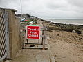
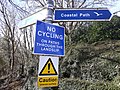 Coastal path warning sign, Isle of Wight.jpg 4,128 × 3,096; 9.59 MB
-
 Coastal Path, Brook Bay, Isle of Wight - geograph.org.uk - 1727039.jpg 1,024 × 681; 274 KB
-
 Coastal Path, Brook Bay, Isle of Wight - geograph.org.uk - 1727055.jpg 1,024 × 681; 508 KB
-
 Coastal Path, Brook Bay, Isle of Wight - geograph.org.uk - 1727107.jpg 1,024 × 681; 304 KB
-
 English Channel from Isle of Wight Coastal path near Niton 2.JPG 4,592 × 3,056; 3.02 MB
-
 English Channel from Isle of Wight Coastal path near Niton.JPG 4,592 × 3,056; 4.26 MB
-
 Entrance to Bouldnor Forest - geograph.org.uk - 604696.jpg 640 × 477; 149 KB
-
 Gurnard beach Coastal Path closure.JPG 4,000 × 3,000; 4.89 MB
-
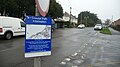 Gurnard Coastal Path closure diversion information.JPG 3,712 × 2,088; 3.29 MB
-
 IOW Coast Path Sign, Sandown, Isle of Wight.jpg 2,016 × 1,512; 744 KB
-
 Isle of Wight Coastal footpath footbridge near Chale.JPG 4,000 × 3,000; 4.84 MB
-
 Isle of Wight Coastal path at Bembridge beach.JPG 4,000 × 3,000; 4.97 MB
-
 Isle of Wight Coastal Path at Compton Bay.jpg 3,072 × 1,728; 1.58 MB
-
 Isle of Wight Coastal Path fencing being built at Lake.JPG 4,000 × 3,000; 4.11 MB
-
 Isle of Wight Coastal path near Niton 2.JPG 4,592 × 3,056; 7.08 MB
-
 Isle of Wight Coastal path near Niton.JPG 4,592 × 3,056; 7.93 MB
-
 Isle of Wight public footpath BS79.JPG 4,000 × 3,000; 4.57 MB
-
 Lake Cliff Path 2.JPG 4,000 × 3,000; 4.5 MB
-
 Lake Cliff Road 2.JPG 3,000 × 4,000; 3.64 MB
-
 Lake Cliff Road.JPG 3,000 × 4,000; 4.08 MB
-
 Niton Undercliff from Isle of Wight Coastal path.JPG 4,592 × 3,056; 6.54 MB
-
 Sea Shore near Bouldnor - geograph.org.uk - 228178.jpg 640 × 480; 99 KB
-
 The view from Culver Down (of Sandown Bay) - geograph.org.uk - 13228.jpg 640 × 322; 182 KB
-
 Thorness Bay in October 2011 3.JPG 4,000 × 3,000; 4.52 MB
-
 Ventnor Coastal Path diversion notice.JPG 4,592 × 3,056; 7.31 MB
-
 Ventnor Coastal Path diversion sign.JPG 4,000 × 3,000; 4.96 MB
-
 Ventnor Coastal Path rock.JPG 4,592 × 3,056; 5.24 MB
-
 Ventnor Steephill Cove in March 2012.JPG 4,000 × 3,000; 4.37 MB
-
 View towards Niton from Isle of Wight Coastal Path.JPG 4,000 × 3,000; 4.75 MB
-
 Whitwell High Hat.JPG 4,000 × 3,000; 4.54 MB
.jpg)


_-_geograph.org.uk_-_13228.jpg)


