Category:Ironbridge Youth & Community Centre, Liverpool
Jump to navigation
Jump to search
| Camera location | | View all coordinates using: OpenStreetMap |
|---|
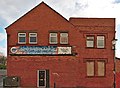
Gym, youth club and community centre at 127 Beresford Street, Dingle, Liverpool 8.
Media in category "Ironbridge Youth & Community Centre, Liverpool"
The following 4 files are in this category, out of 4 total.
-
 Ghost sign at Ironbridge YCS.jpg 4,149 × 2,263; 11.72 MB
-
 Ironbridge Youth & Community Centre, Liverpool 1.jpg 5,027 × 3,302; 18.73 MB
-
 Ironbridge Youth & Community Centre, Liverpool 2.jpg 4,615 × 3,377; 18.23 MB
-
 Mosaic at Ironbridge YCS.jpg 4,894 × 3,427; 24.77 MB


