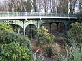
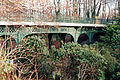
Category:Iron Bridge, Sefton Park
Jump to navigation
Jump to search
| Object location | | View all coordinates using: OpenStreetMap |
|---|
bridge in Sefton Park, Liverpool, Merseyside, UK  | |||||
| Upload media | |||||
| Instance of | |||||
|---|---|---|---|---|---|
| Location | Sefton Park, Liverpool, Merseyside, North West England, England | ||||
| Carries |
| ||||
| Heritage designation |
| ||||
 | |||||
Media in category "Iron Bridge, Sefton Park"
The following 8 files are in this category, out of 8 total.
-
 Benchmark, Sefton Park iron bridge.jpg 3,232 × 2,527; 6.34 MB
-
 Iron Bridge Between Ibbotsons Lane And Queens Drive Junctions.jpg 3,024 × 4,032; 4.24 MB
-
 Iron Bridge, Sefton Park (1).jpg 2,560 × 1,920; 1.25 MB
-
 Iron Bridge, Sefton Park (2).jpg 2,560 × 1,920; 1.65 MB
-
 Iron Bridge, Sefton Park (3).jpg 2,560 × 1,920; 1.63 MB
-
 Iron bridge, Sefton Park 2017.jpg 5,152 × 3,864; 7.61 MB
-
-
 Sefton Park 3.jpg 3,475 × 2,304; 2.09 MB

.jpg)
.jpg)
.jpg)


