Category:Inver, County Donegal
Jump to navigation
Jump to search
village in County Donegal, Ireland  | |||||
| Upload media | |||||
| Instance of | |||||
|---|---|---|---|---|---|
| Location | County Donegal, Ulster, Ireland | ||||
 | |||||

English: Inver, meaning estuary or mouth of river, is a village in County Donegal, Ireland. It lies on the N56 National secondary road mid way between Killybegs to the west and Donegal Town to the east.
Subcategories
This category has the following 2 subcategories, out of 2 total.
I
- Inver railway station (2 F)
O
- Inver Old Church (6 F)
Media in category "Inver, County Donegal"
The following 12 files are in this category, out of 12 total.
-
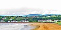 Beachfront at the village of Inver - geograph.org.uk - 924173.jpg 640 × 313; 52 KB
-
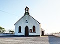 County Donegal - Inver Methodist Church - 20200919182407.jpg 2,112 × 1,564; 644 KB
-
 Dunkineely Donegal Bay geograph-3185376-by-Ben-Brooksbank.jpg 2,316 × 1,372; 2.73 MB
-
 Inver , Railway Underpass - geograph.org.uk - 924802.jpg 480 × 640; 101 KB
-
 Inver Bridge - geograph.org.uk - 830419.jpg 640 × 480; 91 KB
-
 Inver Church - geograph.org.uk - 924821.jpg 640 × 480; 68 KB
-
 Inver Harbour 2012 09 16.jpg 3,372 × 2,055; 4.84 MB
-
 Inver, Co. Donegal - Introducing Jaunty? (33153445835).jpg 2,000 × 1,502; 1.92 MB
-
 Inverdonegal.JPG 3,072 × 2,048; 2.77 MB
-
 O'Neill's , Letterbarrow - geograph.org.uk - 971098.jpg 640 × 427; 83 KB
-
 Strand at St John's Point - geograph.org.uk - 961803.jpg 640 × 427; 80 KB
-
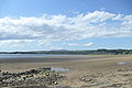
 South end of Inver Beach - geograph.org.uk - 305457.jpg 640 × 420; 96 KB


.jpg)


