Category:Interstate Highway Bridge
Jump to navigation
Jump to search
| Object location | | View all coordinates using: OpenStreetMap |
|---|
English: This category is intended for media related to the Interstate Highway Bridge, a bridge built in 1939 which carries U.S. Route 12 between Lewiston, Idaho and Clarkston, Washington. Alternative names: US 12 Highway Bridge, US 12 Interstate Bridge, Blue Bridge, Snake River Bridge.
bridge in USA .jpg) | |||||
| Upload media | |||||
| Instance of | |||||
|---|---|---|---|---|---|
| Location |
| ||||
| Crosses | |||||
| Carries | |||||
 | |||||
Media in category "Interstate Highway Bridge"
The following 5 files are in this category, out of 5 total.
-
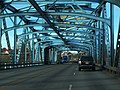
 Crossing the Blue Bridge from Lewiston to Clarkston (2007).jpg 739 × 554; 93 KB
-
 Snake River Bridge between Lewiston and Clarkston (2010).jpg 1,536 × 2,048; 2.91 MB
-
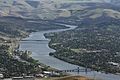 Telephoto of Snake River in Lewiston and Clarkston from U.S. Route 95 viewpoint (2015).jpg 3,888 × 2,592; 6.56 MB
-
 US 12 ID west end.jpg 3,264 × 2,448; 1.73 MB
-
 US12wRoad-SnakeRiverBridgeWashingtonSide (31439533090).jpg 2,400 × 1,800; 1.46 MB
.jpg)
.jpg)

.jpg)
Categories:
- Bridges over the Snake River
- Clarkston, Washington
- Lewiston, Idaho
- Vertical-lift bridges in Idaho
- Vertical-lift bridges in Washington (state)
- U.S. Route 12 in Idaho
- U.S. Route 12 in Washington (state)
- Bridges in the United States completed in 1939
- Interstate Highway bridges
- Bridges in Asotin County, Washington