Category:Insolation maps of the world
Jump to navigation
Jump to search
Media in category "Insolation maps of the world"
The following 19 files are in this category, out of 19 total.
-
 Insolation.gif 540 × 632; 64 KB
-
 Global Solar Atlas 1.0.png 1,917 × 969; 1.8 MB
-
 Global surface brightness temperature. April 2013.png 1,437 × 921; 2.32 MB
-
 Global-Solar-Atlas World PVOUT Solargis.png 1,889 × 1,122; 1.52 MB
-
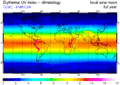 GOME.uviecclimyear lr.gif 676 × 480; 59 KB
-
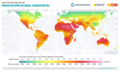
 Img mapa indice ultravioleta.webp 1,984 × 959; 150 KB
-
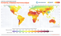
 Insolation with dots.PNG 732 × 680; 24 KB
-
 Insolation.png 691 × 737; 18 KB
-
 RSDS wiki.png 3,543 × 2,530; 1.64 MB
-
 Solar world map.jpg 1,859 × 960; 292 KB
-
 World DNI Solar-resource-map GlobalSolarAtlas World-Bank-Esmap-Solargis.png 1,889 × 1,122; 1.49 MB
-
 World DNI Solar-resource-map lang-ES GlobalSolarAtlas World-Bank-Esmap-Solargis.png 1,889 × 1,122; 1.49 MB
-
 World DNI Solar-resource-map lang-FR GlobalSolarAtlas World-Bank-Esmap-Solargis.png 1,889 × 1,122; 1.49 MB
-
 World GHI Solar-resource-map GlobalSolarAtlas World-Bank-Esmap-Solargis.png 1,889 × 1,122; 1.51 MB
-
 World GHI Solar-resource-map lang-ES GlobalSolarAtlas World-Bank-Esmap-Solargis.png 1,889 × 1,122; 1.51 MB
-
 World GHI Solar-resource-map lang-FR GlobalSolarAtlas World-Bank-Esmap-Solargis.png 1,889 × 1,122; 1.51 MB
-

-
-
 World PVOUT Solar-resource-map GlobalSolarAtlas World-Bank-Esmap-Solargis.png 1,889 × 1,122; 1.37 MB


